Another intensive trip, this time to the area of Leadville, Co., which is located in a basin east of the central part of the Sawatch Range, where are located the highest peaks in Colorado. Members of the team were our classical quartet, me, Dina, Udo and Gayathri.
On Friday afternoon we set out of SLC and after about 3 hour drive to Spanish Fork continued smoothly east. Leaving Spanish Fork at ca. 6.30 pm, we were at Glenwood Springs at 11.30 and took Colorado Hwy. 82 through Aspen and Independence Pass (above 12000 ft.). At around 1 am, we found a spot in a campground about 10 miles east of the pass where we stayed for the next three nights.
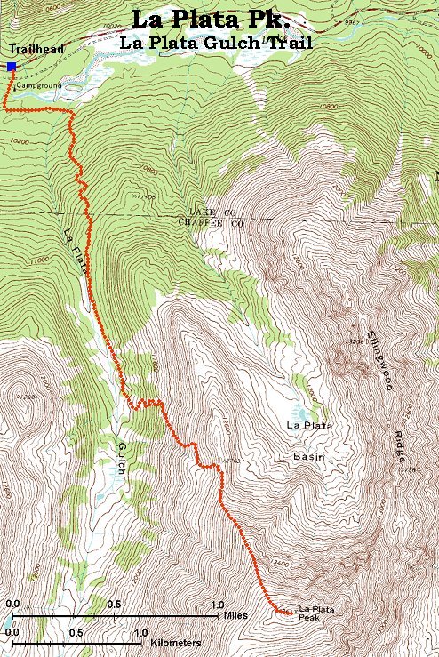
On Saturday we woke up late, and at about 10.30 pm started hiking up to La Plata Peak, from trailhead next to Hwy 82, at 10100 ft. The route, called La Plata Gulch Trail, approaches the mountain from the north and is ca. 4 miles long. First part goes through the forest, up the gulch. After ca. 1.5 miles it starts to switchback east and reaches the ridge at ca. 12800 ft. Then it goes up the moderately steep ridge to the summit, 14336 ft, 4377 m. Since we started late, me and Udo left the girls behind and tried to go fast. We were at the summit in about 3 hours. The descent took about the same time, as we took it easy.
Map of the La Plata Gulch trail (195 kB).
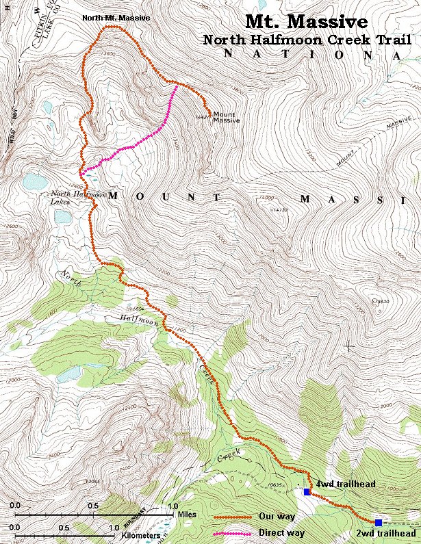
On Sunday the plan was to hike Mt. Massive, 14421 ft., 4395 m., second highest mountain in the state, via the North Halfmoon Trail, approaching the mountain from southwest, supposedly less crowded than the main Mt. Massive trail coming from the east. We got up at 6am, but did not start hiking before 9am, as the access road to the trailhead was quite rough about the last 4 miles. I was mostly driving in the 1st gear, although it still was a bit less rough than Mt. Adams. In about 1.5 hours we got to the upper North Halfmoon Basin, where we lost the trail. We continued directly north and up the ridge hoping that it is the one that leads to the summit. It turned out that we should have turned right (east) before this ridge and go to the cirque enclosed by the Massive Ridge. Instead, we ended up on the ridge that goes north to the North Mt. Massive. Walk on the ridge including climb to the N. Massive took about another 2 hours making a total ascent time around 4.5 hours. I think that going the right way would shorten the trip by at least 1 hr. On the other hand, we got also to the North summit, and then descended down the right way and made a nice loop. On the way back I ended up running around the ridge looking for the girls, as we separated due to different speeds. Shouting and binoculars proved to be useful, the shouts echoed nicely in the Massive cirque. We finished the day in a reasonable restaurant in Leadville.
Map of the N. Halfmoon Creek trail (250 kB).
Monday's plan was to climb Mt. Elbert, 14433 ft., 4399 m., the highest peak in Colorado and second highest in the continental US, and then drive home. We again got up at 6am but had to pack, so we left the campground at about 8am. The trailhead for normal cars is about 1 mile off Hwy 82 near the Lakeview campground about the Twin Lakes reservoir. Another ca. 1.5 miles goes on a 4wd road, which would be at least half way driveable also in normal car (not worse than the road to the Massive-Halfmoon 2wd trailhead). We started at about 8.30 am and took it slowly because the plan was that all of us should reach the summit. We got to the 4wd trailhead in about 1:15 hr, it looked like we were among the last people starting that day. The trail went gently about another 0.5 miles and then started to rise sharply through the forest. It levelled a bit at the treeline, but there were still good 2.5 miles to the summit, which we reached after 2pm. I would say that at my standard speed the summit can be reached in under 3 hours. We spent quite some time at the summit, I left it sometime before 3pm, when it was already getting quite cloudy. We got down to the car in about 3 hours, getting a bit wet from several short showers. We loaded in the car and in about 1.5 hours got to Glenwood Springs, where we stopped at Wendy's and ate for 1.5 hours. Left at 9.30pm and got to Salt Lake at 2.30pm, trafic was light so the only problem was the tiredness from the tough weekend.
Map of the Mt. Elbert trail (250 kB).
U of U / Chemistry / HEC / Voth Group / Cuma / Travel / English / Sawatch 00
URL: http://voth.chem.utah.edu/~mcuma/saw00e.html
Last updated: 6-Sep-00 / mc