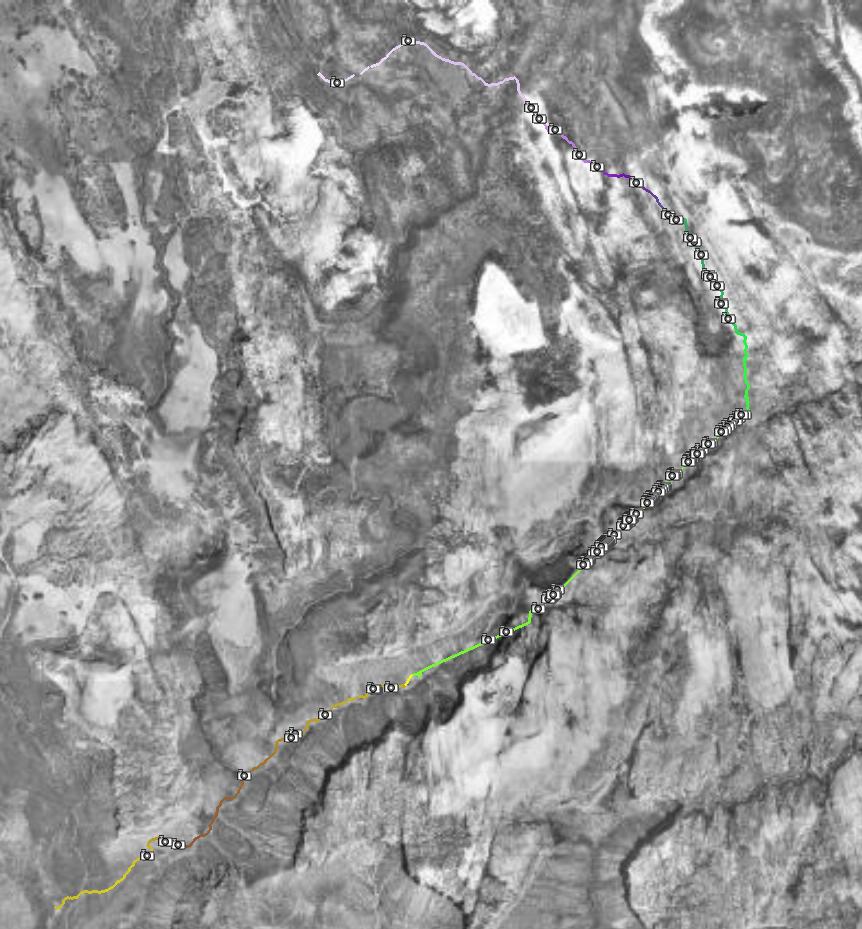
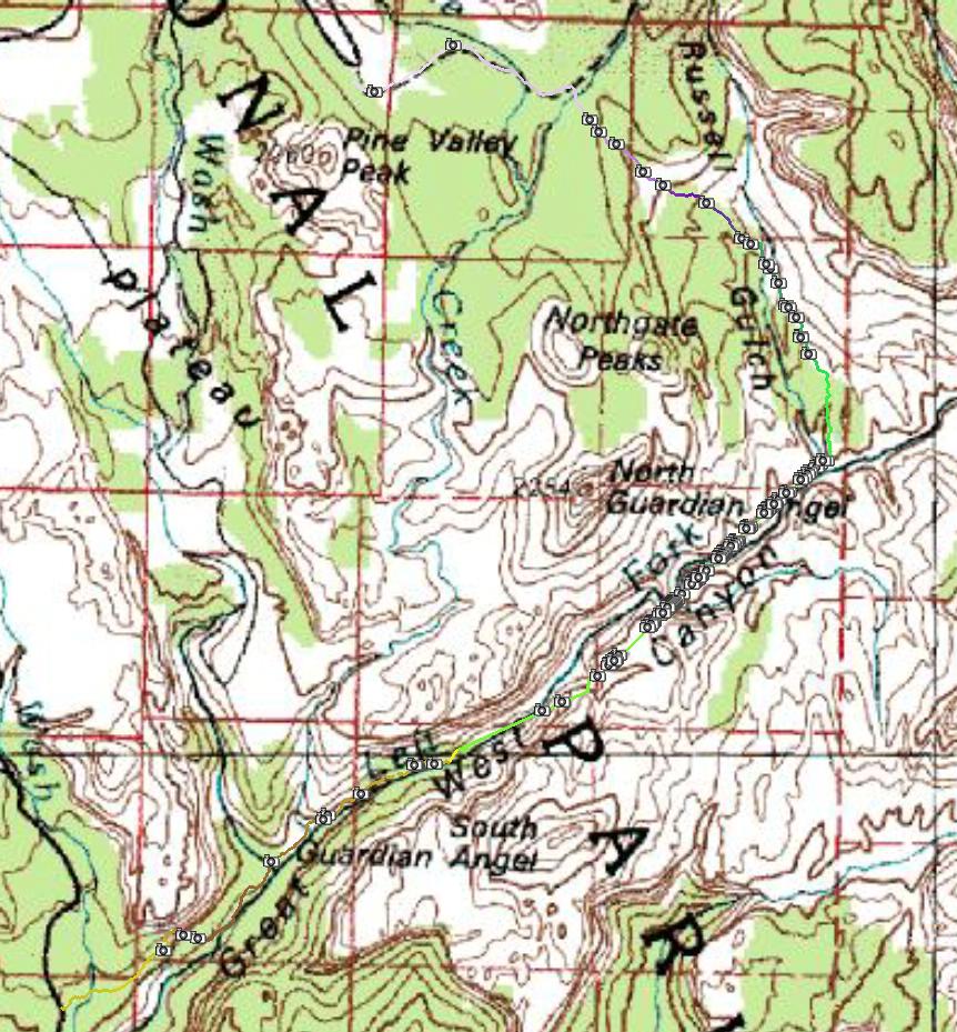
| Details: | A
semi-technical canyoneering route in the western part of Zion. Start at
Wildcat trailhead and head east on Lava Point trail, then descends down
on the east side of Russel Gulch. The descent is cross-country, but
well marked with cairns. Near confluence of Russel Gulch and Left Fork,
the trail descends a steep slope down to Russel Gulch bottom. Here I
lost the GPS signal in the deep canyon and did not regain it till past
the water cascades below the Subway. The trail continues in the slot of
Left Fork, and there are four minor obstacles to overcome. First is
about 3m chokestone, that we bypassed on the right climbing in the
crack between the stone and the canyon wall. No rope required. Then
follows a step into a deep pool, there was a piece of tree that helped
the descend. Otherwise, just jump in the pool. Then follow several more
deep pools with swimming or deep wading. Right before the narrowest
section, there is about 4 m waterfall that jumps into about chest deep
pool. There are anchors for rope there, which we used. This was the
toughest downclimb, as the boulder stuck in the fall created a small
overhang. When I was there four years ago going from the bottom, we
climbed up this on a tree trunk that was stuck in the fall. I also
don't remember the boulder being there, it made the fall about 0.5 m
higher. Below this fall, the canyon is the most scenic, with the slot
being slightly curved in a subway shape. The main Subway, however, is
another 200m below, right below Keyhole Falls, which are bypassed on
the left by about 8 m rapell. There are several anchors in the rock,
that can be used. We had a 30 m rope, which was more than enough. Below
the Subway, there is about a km long stretch of beautiful cascades,
then the canyon opens a bit and one has to only occasionally hop from
one side of the creek to the other. Final attraction is dinosaur tracks
about 3 kms below Subway on white rock slabs on right side of the
canyon, right next to the trail. Then the trail exits the canyon about
another 3 km below on a marked turnoff.
For detailed trail guide and map at Climb-Utah.com, click here |
![[subw001.jpg]](subw001.jpg)
![[subw002.jpg]](subw002.jpg)
![[subw003.jpg]](subw003.jpg)
![[subw004.jpg]](subw004.jpg)
![[subw005.jpg]](subw005.jpg)
![[subw006.jpg]](subw006.jpg)
![[subw007.jpg]](subw007.jpg)
![[subw01a.jpg]](subw01a.jpg)
![[subw02a.jpg]](subw02a.jpg)
![[subw008.jpg]](subw008.jpg)
![[subw009.jpg]](subw009.jpg)
![[subw010.jpg]](subw010.jpg)
![[subw011.jpg]](subw011.jpg)
![[subw012.jpg]](subw012.jpg)
![[subw013.jpg]](subw013.jpg)
![[subw014.jpg]](subw014.jpg)
![[subw03a.jpg]](subw03a.jpg)
![[subw04a.jpg]](subw04a.jpg)
![[subw05a.jpg]](subw05a.jpg)
![[subw015.jpg]](subw015.jpg)
![[subw06a.jpg]](subw06a.jpg)
![[subw016.jpg]](subw016.jpg)
![[subw017.jpg]](subw017.jpg)
![[subw018.jpg]](subw018.jpg)
![[subw019.jpg]](subw019.jpg)
![[subw020.jpg]](subw020.jpg)
![[subw021.jpg]](subw021.jpg)
![[subw07a.jpg]](subw07a.jpg)
![[subw022.jpg]](subw022.jpg)
![[subw023.jpg]](subw023.jpg)
![[subw024.jpg]](subw024.jpg)
![[subw025.jpg]](subw025.jpg)
![[subw026.jpg]](subw026.jpg)
![[subw027.jpg]](subw027.jpg)
![[subw028.jpg]](subw028.jpg)
![[subw029.jpg]](subw029.jpg)
![[subw030.jpg]](subw030.jpg)
![[subw09a.jpg]](subw09a.jpg)
![[subw10a.jpg]](subw10a.jpg)
![[subw031.jpg]](subw031.jpg)
![[subw032.jpg]](subw032.jpg)
![[subw033.jpg]](subw033.jpg)
![[subw034.jpg]](subw034.jpg)
![[subw035.jpg]](subw035.jpg)
![[subw036.jpg]](subw036.jpg)
![[subw037.jpg]](subw037.jpg)
![[subw038.jpg]](subw038.jpg)
![[subw039.jpg]](subw039.jpg)
![[subw040.jpg]](subw040.jpg)
![[subw041.jpg]](subw041.jpg)
![[subw042.jpg]](subw042.jpg)
![[subw043.jpg]](subw043.jpg)
![[subw044.jpg]](subw044.jpg)
![[subw045.jpg]](subw045.jpg)
![[subw046.jpg]](subw046.jpg)
![[subw047.jpg]](subw047.jpg)
![[subw048.jpg]](subw048.jpg)
![[subw049.jpg]](subw049.jpg)
![[subw050.jpg]](subw050.jpg)
![[subw051.jpg]](subw051.jpg)
![[subw052.jpg]](subw052.jpg)
![[subw053.jpg]](subw053.jpg)
![[subw11a.jpg]](subw11a.jpg)
![[subw12a.jpg]](subw12a.jpg)
![[subw056.jpg]](subw056.jpg)
![[subw057.jpg]](subw057.jpg)
![[subw058.jpg]](subw058.jpg)
![[subw059.jpg]](subw059.jpg)
![[subw060.jpg]](subw060.jpg)
![[subw061.jpg]](subw061.jpg)
![[subw062.jpg]](subw062.jpg)
![[subw063.jpg]](subw063.jpg)
![[subw064.jpg]](subw064.jpg)
![[subw13a.jpg]](subw13a.jpg)
![[subw14a.jpg]](subw14a.jpg)
![[subw065.jpg]](subw065.jpg)
![[subw066.jpg]](subw066.jpg)
![[subw067.jpg]](subw067.jpg)
![[subw068.jpg]](subw068.jpg)
![[subw069.jpg]](subw069.jpg)
![[subw15a.jpg]](subw15a.jpg)
![[subw070.jpg]](subw070.jpg)
![[subw071.jpg]](subw071.jpg)
![[subw072.jpg]](subw072.jpg)
![[subw073.jpg]](subw073.jpg)
![[subw074.jpg]](subw074.jpg)
![[subw075.jpg]](subw075.jpg)
![[subw076.jpg]](subw076.jpg)
![[subw077.jpg]](subw077.jpg)
![[subw078.jpg]](subw078.jpg)
![[subw079.jpg]](subw079.jpg)
![[subw080.jpg]](subw080.jpg)
![[subw081.jpg]](subw081.jpg)
![[subw082.jpg]](subw082.jpg)
![[subw083.jpg]](subw083.jpg)
![[subw084.jpg]](subw084.jpg)
![[subw085.jpg]](subw085.jpg)
![[subw086.jpg]](subw086.jpg)
![[subw087.jpg]](subw087.jpg)
![[subw088.jpg]](subw088.jpg)
![[subw089.jpg]](subw089.jpg)
![[subw090.jpg]](subw090.jpg)
![[subw16a.jpg]](subw16a.jpg)
![[subw091.jpg]](subw091.jpg)
![[subw092.jpg]](subw092.jpg)
![[subw093.jpg]](subw093.jpg)
![[subw094.jpg]](subw094.jpg)
![[subw095.jpg]](subw095.jpg)
![[subw17a.jpg]](subw17a.jpg)
![[subw096.jpg]](subw096.jpg)
![[subw097.jpg]](subw097.jpg)
![[subw098.jpg]](subw098.jpg)
![[subw099.jpg]](subw099.jpg)
![[subw18a.jpg]](subw18a.jpg)
![[subw19a.jpg]](subw19a.jpg)
![[subw20a.jpg]](subw20a.jpg)
![[subw21a.jpg]](subw21a.jpg)
![[subw100.jpg]](subw100.jpg)
![[subw101.jpg]](subw101.jpg)
![[subw102.jpg]](subw102.jpg)
![[subw103.jpg]](subw103.jpg)
![[subw104.jpg]](subw104.jpg)
![[subw105.jpg]](subw105.jpg)
![[subw106.jpg]](subw106.jpg)
![[subw107.jpg]](subw107.jpg)
![[subw108.jpg]](subw108.jpg)
![[subw109.jpg]](subw109.jpg)
![[subw110.jpg]](subw110.jpg)
![[subw111.jpg]](subw111.jpg)
![[subw112.jpg]](subw112.jpg)
![[subw113.jpg]](subw113.jpg)
![[subw114.jpg]](subw114.jpg)
![[subw115.jpg]](subw115.jpg)
![[subw116.jpg]](subw116.jpg)
![[subw117.jpg]](subw117.jpg)
![[subw118.jpg]](subw118.jpg)
![[subw119.jpg]](subw119.jpg)
![[subw120.jpg]](subw120.jpg)
![[subw22a.jpg]](subw22a.jpg)
![[subw121.jpg]](subw121.jpg)
![[subw122.jpg]](subw122.jpg)