Here are click-sensitive maps of the trip, divided into two parts. Clicking on the map will show a picture of the area. A word of warning, the maps are at least 500 kB:
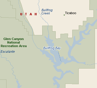
Part 1 Bullfrog - Crystal Springs Canyon.
Part 2 Smiths Canyon - Forgotten Canyon.
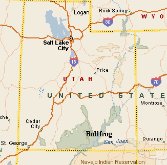
This is a trip that I took with the Outdoor Recreation Program from the University of Utah, which in general has a good offer of water sport trips. This sea-kayak trip ended up to be quite a luxury, because we took a motor raft with us which carried all the additional equipment, including portable toilet, gas stove, coolers with good food,... We left Salt Lake on Wed. evening and arrived to Bullfrog in the central part of Lake Powell well after midnight. We landed at the deserted campground, administered by the NPS. It was fairly warm outside, so I did not bother to build a tent. What was a surprise when it started to sprinkle a bit right after sunrise. It was a rough awakening into a rough day. Thick black clouds were rolling in the sky, but that sprinkle was the only one we had in the day. We ate breakfast, got the stuff together and sometime before 10am arrived to a beach. It took us over another hour to pack up and then we took off. The lake was fairly windy, and sun started to peek out around noon. We made a lunch at a sand bar about 2 miles from the start. Then we continued in a windy afternoon south-east and then east on the nothern side of the channel. In the later afternoon, we explored a little several small bays around the campsite of the day, about a mile east of Moqui Canyon. The evening was pretty windy, but we managed to find several small valleys in which we built the tents and cooked dineer.
We woke up into a nice sunny morning. Before breakfast, I went on a small hill above the campsite and explored a tiny canyon full of potholes that lead to the bay where we camped. By ca. 10am, we set out on the river, which was quite tranquil at this point. After Moqui Canyon, the canyon wall on the left rises quite high while that on the right is fairly flat. Then we crossed the river to another wall on the right side. After about another mile, we found a small bay where we made a lunch. After that is was a fairly fast cruise and in about two hours we were at the mouth of Smiths Canyon, where we found a nice campsite. We unloaded the raft and set out up Smiths Canyon to explore the slot canyon in the upper part. Most of the people sat in the raft, me and Dina took the kayaks. Kayaking in the narrower canyon was quite exciting. It took us somewhat under 1.5 hours to get to the end of the water. Then we walked for about an hour up through the slot. The slot start is at least a kilometer upstream from the lake, and its first part it the highest and best. But it still remains narrow higher up, although not that steep. We turned around when it was getting late. The way back to the campsite on the lake was quite a race, I teamed up with Chris, one of the trip leaders, and we made it back in about 45 min, almost at the speed of the motor raft. But the arms took a hit by this effort. Then we had quite a relaxing evening with a good dinner and a spectacle at before going to bed. Because of the large eruptions on the sun, the northern lights were visible all over the North America. I did not know what that was, it was just a strong red glow in the north, which looked like distant city lights, but there was no city anywhere near. I did not know what that light was until I read a newspaper on Sunday. Probably, we just caught the start of it and if we stayed up longer, we would have probably seen it even better.
On Saturday morning, I went for another small hike to a hill above the campground. From here there was a nice view at the meanders of the lower Smiths Canyon. Then I fooled around a little on the canyon rim and threw some stones down into the lake, which made nice circles on the otherwise tranquil morning waters. After a hearty breakfast, we set out for the way back. Me and Dina, however, decided first to check out Forgotten Canyon on the other side of the river. The canyon would probably take whole day to explore, there are some old Indian ruins in the upper part. We just went in about 1 km, to the end of the right fork which ends in a spectacular alcove. The trafic in the canyon was getting heavy, however, it was a weekend day and the ruins are probably attractive too. The waves created by the motor boats were getting amplified by the canyon walls, so we had to be carefull. On the way back, we checked out a floating toilet, which seemed to be more frequented, than the ruins downcanyon, and then hurried into the main channel and back towards Bullfrog. We met with the rest of the group at the lunch spot about 6 miles down river. After the lunch, we continued all the way to Bullfrog, a total of 12.5 miles which we have done, with a lunch stop, in about 5 hours. We packed up and moved back to the campground and enjoyed some parts of civilization, such as flowing water and flush toilets. The night was not that great, though, it was quite noisy there. On Sunday, we packed up and drove to Green River for lunch and then back to Salt Lake.
U of U / Chemistry / HEC / Voth Group / Cuma / Travel / English / Bullfrog
URL: http://voth.chem.utah.edu/~mcuma/bullfrog01e.html