First spring hiking trip to the desert turned up to be an excellent backpack. Since it was a collective action, I have made a pre-trip webpage, which is here
Here are click-sensitive maps of the three days of backpacking. Clicking on the map will show a picture of the area. A word of warning, the maps are at least 500 kB:
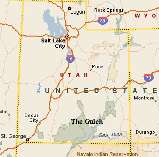
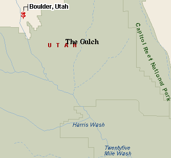
Day 1 The Gulch Trailhead - Boulder Creek - Line shack above Escalante River.
Day 2 Line shack above Escalante River - The Gulch narrows - Horse Canyon.
Day 3 Horse Canyon - Little Death Hollow narrows to the trailhead.
I have planned this trip long time ago in the winter, at times when I was sick of the cold. My main source was Steve Allen's Canyoneering 2 book, I took his Escalante East trip and shortened it to 3 days. I must say, that his description of the cross-country parts of the hike were pretty good, although topo map and compass proved to be useful too. It ended up that only me and friend Christoph did the whole thing, two other friends, Gabi and Ivan did a shorter version down Wolverine Canyon and up Little Death Hollow, meeting us at the second camp at Horse Canyon on Saturday evening.
We set out from Salt Lake Thursday around 6.30pm and arrived to the Gulch trailhead about 15 kms east on Burr Trail road around 11pm. The drive was, as usual, quite uneventful. We made a tent right at the trailhead parking lot and went to sleep.
On Friday, we woke up to partly cloudy skies, which surprised me, since the forecast was saying overcast and 50% of rain. We packed up and set out around 9.30am, immediately climbing up the slope to the western rim of the Gulch. In about 1 hour, we got to the highest hill around, from which were great views. Then we set downhill in the south-western direction, following a wash between the Gulch and Deer Creek. There were several potholes with water, and quite a bit of vegetation on the bottom. After about 45 min, the wash became quite bushy and we went up the slope on its west side. After realizing, that we went up too early, we just continued on the slickrock bench for another 1.5 hours until we came to a shallow valley in the slickrock plateau that was full of potholes, which made nice looking oases in the desert of flat sandstone. After having a lunch beside one of them, we followed the valley to a point where it drops 20 m into Boulder Creek. The creek was full of water and we explored it from the rim. Then we headed south-east over a small ridge and down a steep chute into another valley, that leads to Boulder Creek. However, we were surprised to see another, ca. 10 m dropoff to the creek valley. After some searching around, we found that one can go south on a higher plateau about 250 m until reaches narrow valley that comfortably leads down to the creek (this part was not too clear in the book). The book further says to take a nearby slot up out of the creek valley into the plateau above Escalante River. We missed the slot at the first shot, walking down the creek for several minutes. It is maybe 20 m. dowstream from the entry valley and heads north-east. The slot was not too steep, only once we had to hand the backpacks to each other. After getting out of the slot, it was about 20 min. walk to the line shack on a cliff above Escalante River. We set out a camp, and walked to the river on an old trail to refill water. The river water was pretty silty, I managed to clog my filter quite a bit because I forgot to put cofee filter over the water input. Since it got pretty cold after the sun went down, we were in bed by 8pm.
The sun woke us up at 8pm, and it took us 2 hours to pack up and eat. Then we walked across the sand covered plateau towards the Gulch. We decided to shorten this part out by skipping the highest part of the narrows, because the day was planned to be pretty long anyway. We reached the Gulch rim in about 1.25 hr. Then we had to walk around the bend of the canyon (where is supposedly a waterfall) for a while and after some effort, thanks mostly to previous tracks in the sand, found a trail down into the canyon. I wanted to go upstream to see the waterfall, however, we were stopped about half way by deep water. The narrows in this area were about 2 m. wide and the water varied from ankle deep to about waist deep, at which point we gave up. It was too cold and yucky for swimming. Then we walked down the Gulch for several miles, or 2.5 hrs. Wading shoes were required, because one had to cross the creek numerous times and sometimes it was easier to walk in the creek than struggle through thick bushes on the bank. The recommended way out was via one of three slots that are pretty easily reckognizable, about a mile upstream from the estuary to the Escalante. We found out, that the central, no. 1 pick by Allen, was not that easy because at the bottom was about knee deep pothole and ca. 2 m. dropoff. The third one, his second pick, proved to be much easier. We entered it on a ledge about 20 m. above the Gulch and continued up. The only obstacle was one boulder jam, which required some scrambling. We got to the ridge between slots 2 and 3 as soon as possible, as recommended by the book, and after about 1 hr. of walk directly east turned out to be at the rim of Horse Canyon. The decend down on the old cattle trail was probably the only good one around, it was long and steep and the walls around did not look that easy. We found Ivan and Gabi's tent few hundred meters down the stream from our canyon entry, at the right time, since it was already about 5.30. They showed up soon after our arrival, we made the camp, cooked dinner, drank some tea with slivovice and went to bed.
Gabi woke us up pretty early, about 7am. We were freezing around till 9am, the sun had a hard time to get around the high canyon walls. We set out somewhat after 9am and in less than 30 min entered Little Death Hollow. It is reasonably wide only for a little while, and narrows into about 2 m wide slot which was full of water pools. Fortunately, it was easy to bypass it on a ledge on a left side (upcanyon). After several hunded more meters we descended into the canyon, which varied in width between 2 and 4 m. There were 3 chokestones in the lower part, which we had to overcome by handing backpacks to each other. The last one was especially anoying since it was sitting in mud, which made climbing over it more difficult. Then the canyon floor varied from gravel to mud to water pools. We managed to get around most of them by spreading legs and arms and climbing over them, the canyon was pretty narrow. I ended up wading one of the pools, which walls were pretty steep and I did not trust my stability with heavy backpack. Ivan and Christoph managed to get through with dry feet. The central part of the narrows was the narrowest, I sometimes touched both walls with my backpack. Then the canyon varied between narrow and reasonably wide, with several side washes coming in on both sides. At the upper part, there was a huge chokestone, which was easy to walk under, though. The last piece of the narrows was marked by high walls and several alcoves. Then the canyon widened up and the floor consisted of sagebrush and sandy brown soil devegetated by the cows. We followed one of their paths to the trailhead, which took about an hour. The whole narrows were probably the longest I have been in so far, with lunch it took us 4 hours to get through. The rest of the trip was, again, driving home, quite uninteresting and uneventful.
U of U / Chemistry / HEC / Voth Group / Cuma / Travel / English / Gulch
URL: http://voth.chem.utah.edu/~mcuma/gulch01e.html