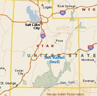
Thu. 5/24 - Drove out of SLC at ca. 7pm, arrived to Hidden Splendor Mine around midnight.
Fri. 5/25 - Hiked the Chute of Muddy Creek, using an inovative bike-shuttle system. In the late afternoon, biked to pick up the car.
Here is the photo tour of the hike
Sat. 5/26 - Hiked loop Ramp Canyon - Cistern Canyon, then drove to Tan Flat area and camped.
Here is the photo tour of the hike
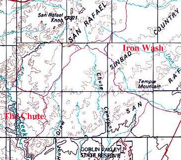
Sun. 5/27 - Mountain biked on the Iron Wash area motorcycle trails. Then drove home.
Here is the maps and images from the ride
We left SLC at a standard time, and the whole drive had standard timings, until we hit the dirt road south of Temple Mountain. The progress slowed down considerably, and it took us over an hour to get to Hidden Splendor Mine, about 30 miles away. Then add another 15 min. or so for looking (without success) for a shady campspot, and we got to bed way past midnight.
On Fri. morning, I got up fairly early, as I knew that there was a long day ahead of us. The plan was to hike down the Chute of Muddy Creek, starting at Tomsich Butte, about 17 road miles and about the same amount of creek miles away, and finishing back here, at Hidden Splendor. Since we had just one car, I decided for the first time use the innovative technique of a mountainbike shuttle. I locked my mountain bike to an old piece of mining machinery, and we drove the car to Tomsich Butte, and left it there. I figured, either we finish the hike at reasonable time and I manage to bike back for the car in the evening, or in the morning. In case we would be late, we left all the stuff needed for the evening at Hidden Splendor (that included tent, sleeping bags, cooler and stove). Here is the photo tour of the hike.
It took us a bit over 30 min. to drive to Tomsich Butte, and around 8.30am we set out hiking. It's a good idea to put wading shoes on right away, and not even bother carrying hiking boots. The creek needs to be crossed countless times, from the very start to the very end. I have checked the creek flows, as measured on the flow stake in Emery, 50 miles away, on the internet. It was flowing at around 140 cfs, which is not too high, but not too low either. God knows what was the flow in the Chute, as farmers upstream are catching the water for irrigation, but, the creek seemed pretty high to me. It got me a bit worried at the first crossing, which was only about mid-calf deep, but the current was fairly strong. The guides say that in high water, there is an option to bypass the narrows on a track west of the Chute. We decided to keep going, and if things get bad, we get out and walk the inland route. It took us about an hour and about 6 creek crossings to get to the first narrow area. In the open space, horse flies were getting annoying, but only mildly. It was enough to swat them once in a while. The highlight was a group of wild horses on the western rim of the canyon, they ran away when they saw us.
The first narrows, according to the guide books, may contain some deep pools, requiring swimming. We were ready for that, backpack lined with trashbags, and dry clothes in it, but it never came. Instead, we got used to wading in knee-deep water and the progress was smooth. The only complaint would be the water quality. Not only it was muddy, but it smelled like urine or similar yucky substance.
After about 45 min, the canyon opened up, and we again walked more on the banks than in the creek. This wider section took about an hour to pass, and then started the second, long and tall narrows, cutting through the Coconino sandstone. Some sections required more wading, some less. On average, in the upper part of the narrows one spent about 50% of the time in water. Often there was a long stretch of wading followed by several creek crossings and walk on a muddy or gravely bank beside the canyon wall. In about 1.15 hrs. in the narrows, we got to a place where a large boulder sits in the middle of the creek. I would say from here start the deepest narrows. In another hour, there is an alcovy turn with a water seep, and in another 30 min. comes the log jam, noted by all the guide books as the narrowest and deepest spot. I am not sure about that, the area around there was definitely the deepest, with water up to mid-thighs high. We had a late lunch on a sand bar about 10 min. upstream from the log jam. Past the log jam, there are a couple of nice narrow turns, and in about 30 min. comes the end of the narrows.
What follows then is a walk on one or the other bank and periodic creek crossings. The walk down is fast, the canyon is still entertaining, and there was variety of spring flowers on display, so, good time continued past the narrows. However, the old running shoes, that I used for wading, were not the best thing to wear on prolonged dry stretches (although, changing shoes at every crossing would be even worse option), so, we were happy to see the Hidden Splendor area in the end. We got to the camp at about 5.15pm, with probably 8 hours of hiking time.
I have rested a bit, had a beer, and at 6pm took of on the bike to pick up the car. The 17 miles of road consist of 10 miles of gradual ca. 500m vertical climb to McKay Flat, and then descent down to Tomsich Butte. Fortunately, it was somewhat cloudy, so it was not too hot. It took me an hour to do the first 10 miles, 15 min. to do the remaining 7. Cruising down at 50 km/h was a reward for the arduous climb. The drive back took again somewhat over an hour, so, I was back by 8pm, just ready for the dinner. After a day like this, we went to bed pretty early.
On Saturday we slept longer, till ca. 8am. Before we got around, it was getting quite hot and small gnats were especially annoying, flying around head and getting and biting in the hair. So we decided to pack up, and have a breakfast at the trailhead for Ramp Canyon. This was a change of plans, since initially I thought on hiking down Muddy Creek through San Rafael Reef and back the same way. But we had enough of wading, and prospect of wading several miles against the current was not inviting either. So we opted to do a loop hike through the Reef, down Ramp Canyon and up Cistern Canyon. Here is photo tour of the hike.
Access to Ramp is pretty easy, drive from Hidden Splendor for 2.3 miles and turn right on a doubletrack. Follow this for 1 mile to the mouth of Ramp. However, there was a rough spot about 0.2 miles from the road, which I did not dare to cross (it probably could have been done, but I did not feel like taking the risk for saving a mile of walking). So we parked near the road, had a breakfast (gnats were still annoying, but less than at Hidden Splendor) and set off. As can be seen from the pictures, Ramp does not have a real slot section. The upper part consists of bouldery area, followed by several rock slabs an twists. In about middle of the canyon is a large chokestone with ca. 5m dryfall. One guide suggests bypassing that on a ramp on the left side, that seemed to me too risky as the rock on the ramp was slippery. Other option is to wedge between the chokestone and the canyon wall and go down to about 2 m above the ground, where the chokestone ends, and then jump down. The worst part was the lowest part of the chokestone, which is somewhat tilted in unfavorable angle. I must say it was not too easy, but doable. After Dina saw my troubles, she decided to turn around, and I don't blame her. This one is not for beginners.
The trouble spots did not end with the dryfall. About 200m below was a series of 3 potholes. In the first two I did not see any other option than getting in them, so, boots off and jump in. The first one was about 1m deep, the other about 0.5m. Take a stick with you to probe the water level before you get in. The third one was easily bypassed. The last trouble spot was about 100m below the potholes, two dry potholes with a fall to get into them. The first one was about 2 m. high, and inclined towards the slope, so I had to jump all the way down. Fortunately, the landing to the sand at the bottom was soft. The other one was not that steep. I can see a problem of getting up the first one in case somebody would want to hike up, instead of down, but, probably, after some effort, this obstacle can be surpassed.
There were no more surprises till the exit from the Reef. The Ramp wash continues to the right, to get to Cistern, turn left into the first prominent wash and walk it up for a while. I think I have walked too much, though, since it started turning towards the Reef. So I exited the wash and walked uphill in the north-east direction for quite a while (30-45 min), crossing about 5 minor canyons, until I got to a ridge about 80 m above Cistern Canyon. I think an easier way would be to exit the first wash right when it starts turning to the Reef and its walls are still small, and walk in the north-east direction across the more minor hills below the Reef. You save yourself some climbing.
Cistern Canyon is not too exciting, there are several narrower sections, but nothing as narrow as Ramp. There is a cool chokestone in the lower part, under which one can easily walk. The upper part of Cistern is marked with numerous ATV track, as it is easily accessible from the Behind the Reef Road, now turned into ATV road. The advantage of this is, that the track climbs up west towards Ramp, providing a fairly quick return option and conclusion of the loop. The only disadvantage was that I did this part in the middle of the day when it was pretty hot. I think, that in total, it took me about 5 hours to do the whole loop.
After this, we drove to the upper Swell, in particular in the Tan Flat area, where I planned to ride my bike on Sunday (see the map from Sunday), and spent the rest of the afternoon relaxing in the shade of a juniper. In the evening, when it cooled down a bit, I rode about 3 miles from our campspot to the trailhead of Green and Blue trails, just to check out how the road looks like. This is a very nice area, grassy meadows dotted with junipers, and the road winding through them as it was a singletrack. There were some rocky sections, but nothing too difficult.
Sunday was the riding time. The plan was to bike a loop covering about half of the Iron Divide motorcycle trail system trails, and then return back to the camp and drive home. As a guide, I have used phenomenal Gregg Bromka's book, with slight modifications. Take a look there for the trail directions,... Pictures from my ride and a map are here.
I was happy to wake up and see cloudy skies. It was a very pleasant warmup to bike those 10kms or so from our camp to the Red trail trailhead. Then all hell broke loose. The Red trail is marked as difficult, and for a reason. The trail goes over bumpy slicrock, drops into ravines and crosses sand pits. I must admit I was dismounting quite often. The trail is great, but the motorcycles have churned it quite a bit, and there were often loose rocks and sand on the slickrock slopes, which made me worried that my tires will skid (this happens very easily). It took me probably around 45 min. to cover those 3 miles and drop into Iron Wash. The problems did not end here. The motorcycles have churned also the small gravel in the wash and the bike was often sinking 10-15 cm deep. Push and ride was the action. After about 0.5 miles, the trail exits the wash, meets with Orange Trail and conditions return to normal.
Orange Trail consists of only occasional patches of slickrock with fast, gravel covered trail, that probably used to be singletrack a long time ago, but was now widened by unskilled motorcyclists to about 1.5-2m. Still, it was fun. I passed the junction with Blue Trail, followed by somewhat technical climb up to a small ridge and then descended crossing two washes (I had to walk down into the first one) and then going up the third for about a mile. Ride up this wash was fun, mix of slicrock slabs and hard packed gravel. In this wash is the intersection with Green Trail, where I met 2 mid-age bikers from SLC, the only people on the trail that day. Another short climb to a ridge and then several miles of fast downhill, first on the hills, and then dropping into a wash, that leads all the way to the trailead in Farnsworth Canyon, several miles north of Temple Mountain. There was a lone SUV of the bikers I met, but no ride for me.
What followed was a climb out of Farnsworth and drop into North Temple Wash, and then ride up around North Temple Mountain. I originally planned to take a shortcut on the way back and ride on a doubletrack, that heads north-east from Temple Mountain, but I have missed it, so I ended up just riding around the mountain, then dropping down to the main dirt road and riding up towards Flat Top Mtn. and back to the campsite. This last stretch was quite unpleasant, it was a constant climb, in baking mid-day sun, but, a symbolic way to finish an epic ride. Total loop length about 62 kms, 5 hours (4 hrs. riding time), about 1200 m elevation change.
U of U / Chemistry / HEC / Voth Group / Cuma / Travel / English / Swell 01
URL: http://voth.chem.utah.edu/~mcuma/swell01e.html