| Name: | Mc Dowell Mountain Preserve | 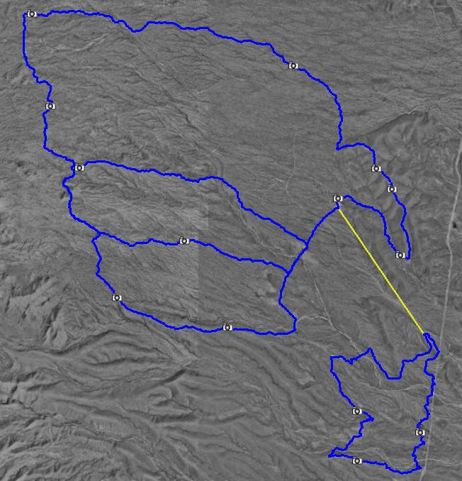
|
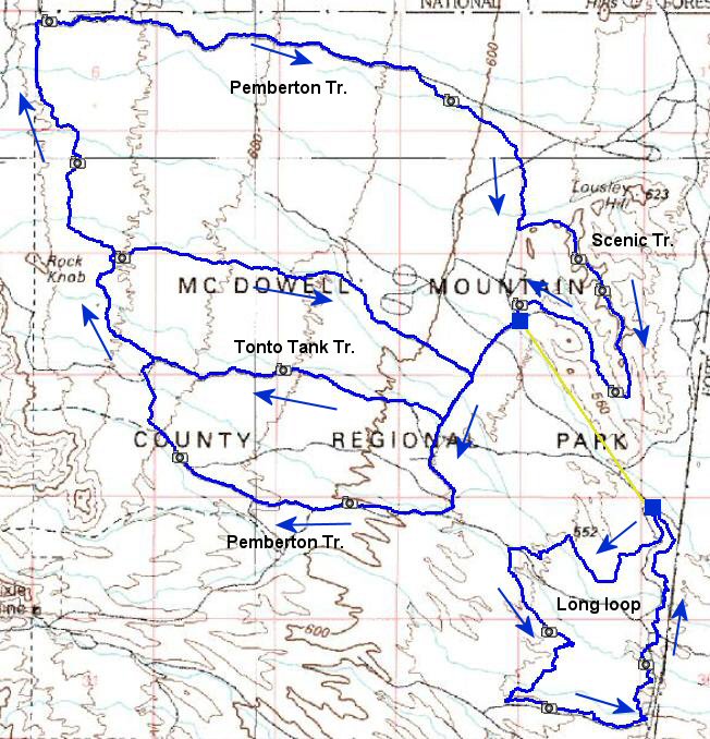
| Details: | Mc Dowell Park is located northeast of Phoenix, at the end of the sprawling city. Thus it takes about an hour of driving from the downtown to get there, a fast that I did not think of when I went. Another deterrent is $5 entrance fee. There is about 45 miles of trails, mostly pretty smooth and fast singletrack (most of it is actually pretty wide, about 1 m - USFS standard trail size). A positive is pretty scenic desert, with a lot of cacti and other bushes. I rode first most of the trails in the main park in a double O loop fashion, that was about 25 miles, and probably preferred way. Closer to the park entrance entrance is competitive track area, which consists of three loops, long, short and techical. I was pretty tired from hammering the previous 25 miles, so, I just rode the 7 miles long loop. The short and technical are supposed to be 3 miles each. | |
| ||
| Trip Length: | 34.92 miles |
| Total Trip Time: | 3:20 |
| Total Climbing: | 3097 feet |
| Total Descending: | 3331 feet |
| Average Speed: | 10.56 mph |
![[mc_dow1.jpg]](mc_dow1.jpg) mc_dow1.jpg 140189 bytes 800 x 600 |
![[mc_dow2.jpg]](mc_dow2.jpg) mc_dow2.jpg 120901 bytes 600 x 800 |
![[mc_dow3.jpg]](mc_dow3.jpg) mc_dow3.jpg 143431 bytes 800 x 600 |
![[mc_dow01a.jpg]](mc_dow01a.jpg) mc_dow01a.jpg 274772 bytes 1912 x 498 |
![[mc_dow02a.jpg]](mc_dow02a.jpg) mc_dow02a.jpg 215873 bytes 1324 x 547 |
![[mc_dow03a.jpg]](mc_dow03a.jpg) mc_dow03a.jpg 260212 bytes 1803 x 538 |
![[mc_dow04a.jpg]](mc_dow04a.jpg) mc_dow04a.jpg 193830 bytes 1304 x 559 |
![[mc_dow05a.jpg]](mc_dow05a.jpg) mc_dow05a.jpg 245508 bytes 1808 x 520 |
![[mc_dow06a.jpg]](mc_dow06a.jpg) mc_dow06a.jpg 296409 bytes 1858 x 546 |
![[mc_dow07a.jpg]](mc_dow07a.jpg) mc_dow07a.jpg 223841 bytes 1310 x 561 |
![[mc_dow08a.jpg]](mc_dow08a.jpg) mc_dow08a.jpg 217121 bytes 1413 x 571 |
![[mc_dow09a.jpg]](mc_dow09a.jpg) mc_dow09a.jpg 205303 bytes 1282 x 552 |
![[mc_dow10a.jpg]](mc_dow10a.jpg) mc_dow10a.jpg 198613 bytes 1286 x 543 |
![[mc_dow11a.jpg]](mc_dow11a.jpg) mc_dow11a.jpg 253804 bytes 1808 x 546 |