Monitoring the Great Salt Lake
John Horel
Professor, Department of Meteorology
Overview
 Selected Sources Regarding the Great Salt Lake
-
Physiography and Variations in Lake Level
-
The Stansbury expedition of 1850
-
Chemistry of the Great Salt Lake
-
Biology of the Great Salt Lake
-
Thermodynamics of the Great Salt Lake
Current Monitoring Over the Great Salt Lake
-
Future Monitoring of the Great Salt Lake
AVHRR Lake Temperature:
Selected Sources on the Great Salt Lake
 The Great Salt Lake. U.S. Geological Survey
-
Commonly Asked Questions About Utah's Great Salt Lake. Utah Geological Survey
-
The Greater Salt Lake Ecosystem. Westminster University
-
Great Salt Lake Planning Project. State Department of Natural Resources
-
The Great Salt Lake.Dale Morgan. 1947. University of Nebraska Press. Lincoln Nebraska. 432 pp.
-
Great Salt Lake. A Scientific Historical and Economic Overview. Edited by J. Wallace Gwynn. 1980. Utah Geological and Mineral Survey. 400 pp.
Physiography and Variations in Lake Level
 Great Salt Lake from USGS
-
Terminal basin of the Great Salt Lake includes the Provo, Weber, and Bear River drainages
-
Present elevation of the Great Salt Lake is 4202 feet (1281 m)
-
16,000 years ago, Lake Bonneville's elevation was approximately 5100 feet ( 1550 m)
-
During past 10,000 years, lake has fluctuated between 4240 feet and 4180 feet
-
During historical record, lake has fluctuated between 4212 feet (1985) and 4192 feet (1964) (USGS)
The Stansbury Expedition of 1849-50
 First detailed weather observations on the Great Salt Lake
-
Captain Howard Stansbury was instructed by the Army to conduct a mile-by-mile survey of the Great Salt Lake and adjacent regions
-
Other participants:
- second-in-command John Gunnison
- crew forman Albert Carrington
-
Examples of weather observations on the Great Salt Lake:
- May 1. Sunrise 57F, cirrus. Noon 71F cirrus. 3 PM 69F cloudy. Sunset 63F calm
- April 16. About 4 oclock a violent gale came up accompanied by thunder and lightning from the west which instantly prostrated most of our tents and a copious fall of hail mingled with rain which wetted the party to the skin.
- May 8. Gunnison Island. We set out at 5 oclock on our return. When within 3 or 4 miles of camp a most furious gale of wind broke down upon us from the NW, which soon raised such a sea as to render the progress of our heavy boat so slow that we did not reach camp until 10 clock, cold tired & hungry.
-
Reference: Exploring the Great Salt Lake: the Stansbury Expedition of 1849-50. Edited by Brigham D. Madsen. University of Utah Press. 1989. 889 pp.
-
Other notable surveys: Grove Karl Gilbert. 1887-80. U. S. Geological Survey.
Chemistry of the Great Salt Lake
-
Much of the salt in the Great Salt Lake was originally suspended in Lake Bonneville while some dissolved salts flow into the lake each year
-
Prior to the completion of the causeway in 1959, the Great Salt Lake was a relatively homogeneous saline lake
-
Now, even with larger openings in causeway created in 1984, Gunnison Bay (north arm) is quite different from Gilbert Bay (south arm). See the accompanying table.
-
U.S.G.S. samples lake monthly
-
When differences in height of Bays are large, head drives surface flow of lighter water near surface into North Arm through gaps
-
When differences in salinity of Bays are large, deep flow of saltier water flows from North Arm into South Arm through permeable causeway
-
Small (1 foot) difference in height now; surface flow through causeway is from north to south as a result of density differences
-
During winter (prior to record lake levels), mirabilite (sodium-sulfate compound) precipitates out in the North Arm. As water warms, layer of mirabilite goes back into solution and forms sulfur-rich layer near bottom that persists and may flow into South Arm
-
During summer, sodium chloride precipitates on floor and will remain on floor until salinity decreases significantly
-
Strong wind storms may cause hydrogen-sulfide rich bottom layers to be mixed to surface and contribute to "Lake Stink" as well as expose decomposing sulfur-rich mud flats
Biology of the Great Salt Lake
Two primary habitats:
-
Surface layer
- Algae blooms during winter
- Brine shrimp hatch from hard-walled eggs (cysts) in April and graze phytoplankton
- Shrimp grow and reproduce during summer molting in as many as 12 different stages
- When shrimp stressed by lack of food or environmental conditions, they switch from producing live young to cysts
- Cysts harvested commercially during Fall and persist in a semi-dehydrated state until the salinity decreases in spring
- No live brine shrimp survive temperature below 5C (42F)
-
Bottom layer
- During spring, shrimp consume enough phytoplankton for light to penetrate to depths
- Photosynthesis by algae in bottom layer provides source of food as well as detritus falling from surface water
- Two species of brine fly spend larval period on bottom of lake
- Flies emerge as adults in early summer
- 110 billion flies plus 10 billion pupae are estimated to hover over 300 miles of beaches (370 million flies per mile of beach)
- Flies consume algae and waste equivalent to a 78,000,000 gallon per day waste treatment plant
Thermodynamics of the Great Salt Lake
-
Annually averaged vertical profile of temperature
indicates that North Arm is warmer near the surface and cooler at depth than the South Arm
(source: unpublished summaries provided by W. Gwynn, Utah Geological Survey)
-
Annual cycle in temperature
of the South Arm
(source: unpublished summaries provided by W. Gwynn, Utah Geological Survey)
indicates:
- Surface temperature varies from 33.9 F in January to 79.3F in July
- Top 20 feet fairly well mixed during year
- Thermocline (warm water above cold depths) evident at 25-30 feet from April-August while
higher temperatures at depth from October-February
- Warmer water at depth is possible, since salinity increases slightly with depth (density more sensitive to salinity than temperature)
-
Implications for the atmosphere of thermodynamic structure:
- Strong winds and upwelling bring colder water to surface from April-August
- Strong winds and upwelling bring warmer water to surface from October-February
- lake-effect snowstorms may be more persistent during Fall-early Winter than late Winter-Spring
since strong winds in post-frontal environment do not cool off lake significantly
Current Monitoring over the Great Salt Lake
-
Utah Mesonet
-
Project began during 1994 in cooperation with National Weather Service
-
On-line information:
University of Utah
-
Surface observations obtained from
local, state, and federal agencies and private firms
-
Data retrieved, processed, and displayed every 15 minutes
-
Goals:
- provide access to weather information in a timely fashion for operational decision makers and the public
- archive and utilize weather data for research and education related to understanding weather phenomena in the intermountain region
-
Unique Aspects of the Utah Mesonet
-
Relies on
local, state, and federal agencies and private firms
to provide most of observations; limited number of stations deployed to fill data voids
-
Cooperating agenices bear the cost of installing, maintaining, and upgrading equipment and communication costs for the most part
-
Surface observations are combined with other observations to provide a 3-dimensional analysis of the atmosphere for a limited domain of northwestern Utah
-
Applications of the Utah Mesonet: Utah ARPS Data Analysis System (ADAS)
-
Local analysis at high temporal (1 h) and spatial
resolution ( 1 km)
-
On-line Information:
ADAS
-
Provide near real-time high resolution data over the complex terrain of northwes
t Utah
-
Based on the Oklahoma ADAS (ARPS Data Analysis System) developed by
the Center for Analysis and Prediction of Storms (CAPS)
-
Incorporation of large-scale and local data:
-
Rapid Update Cycle Version 2 (RUC2) analysis used to initialize ADAS
-
Utah Mesonet available at 15 minute intervals
-
NWS rawinsonde provides upper air data at 0 and 12 GMT
-
NWS WSR-88D velocity and reflectivity data obtained at 5-10 minute intervals (NIDS products)
- Visible and IR Satellite imagery used to specify cloud water
-
Continued Development of ADAS:
- Incorporate other data sources:
- Dugway profiler
- ACAR ascents and descents
- FAA terminal doppler radar
- Level-2 radar data from KMTX
- GOES sounding information
-
Use ADAS to initialize the Advanced Regional Prediction System (ARPS) to provide
high resolution forecasts of mesoscale events.
-
Physical Linkages Between the Great Salt Lake and the Atmosphere
-
Moisture flux
-
Sensible heat flux
-
Stability
-
Surface roughness
-
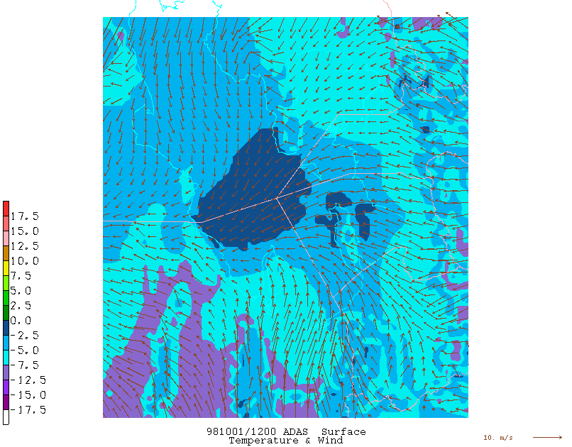
Examples of Current Monitoring and Analysis over the Great Salt Lake
Future Monitoring of the Great Salt Lake
-
Weather support for 2002 Winter Olympics requires high-resolution numerical guidance
-
Lake remains large data void in northwestern Utah
-
Considerable need to have reliable measure of lake temperature in open water forinitialization of forecast models
-
Lake temperature sensor placed off Hat Island was expected to be temporary and communication to sensor is beginning to fail
-
Collaborative project underway with Woods Hole Oceanographic Institution and State Department of Wildlife Resources to place buoy on the lake
-
Parameters to be measured and available every hour:
- Surface air temperature
- Total solar radiation
- Surface lake temperature
- Lake temperature at 3, 5, and 7 m depth
- Photosynthetically Active Radiation (PAR)
- Chlorophyll
- Turbidity
-
Interested in developing collaborative relationships with other researchers to study the Great Salt Lake