
Penetration of Lake Breeze
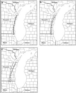
Fig.
3. Mean positions (solid lines) of
the western shore lake breeze for (a)
1800, (b) 2100, and (c) 0000 UTC.
The verification points (1–10)
are indicated by the large dots. Also
shown are
the 18–24-h
MM5 forecast means for the same
set of cases (dashed lines).
County lines and state boundaries
are also depicted for geographic
reference.
Roebber and Gehring (2000) WAF