A trip to the US Northwest
This was a quite intensive trip that I took with my Czech friend S·rka in the end of August 2000.
Here is the trip plan (map):
Fri. 18.8: Drive from SLC on I15 and I84 and stay overnight in the Blue Mountains area in central eastern Oregon.
Sat. 19.8.: Continue drive to the Columbia Gorge area, hike around the Multnomah Falls, drive to Trout Lake, camp in the forest near Trout Creek USFS campground.
Sun. 20.8.: Rest day waiting for the good weather around Mt. Adams. Hike to Sleeping Beauty, a nearby volcanic hill, then drive around Trout Lake and checking out volcanic areas there.
Mon. 21.8.: Climb Mt. Adams via the South Climb route (from 4am to 3pm), then drive towards Mt. Rainier NP and camping in the USFS campground before the Stevens Cyn. entrance.
Tue. 22.8.: Hike the Skyline trail in Mt. Rainier NP, drive to Cougar, Wa. to get the Mt. St. Helens climbing permit, camp at the Climber's Bivouac trailhead.
Wed. 23.8.: Hike Mt. St. Helens via the Monitor Ridge trail (6am to 12.30pm), then drive to the Olympic Peninsula, camping at the Sequim Bay SP..
Thu. 24.8.: Hike in the Olympic Mountains off the Hurricane Ridge area, drive to Ozette, camping at the Lost Resort campground just off the NP (the NP campground was full).
Fri. 25.8.: Hike the Ozette Beach loop, drive to the Quinault area of the Olympic NP and staying at the USFS campground on the south shore of Lake Quinault.
Sat. 26.8.: Walk a short nature trail in the Quinault rain forest, drive to the Cape Disappointment, checking out lighthouses and Lewis & Clark expedition museum. Then drive thru Portland, Or. to the campsite in the Blue Mountains.
Sun. 27.8.: Drive back to SLC, on the way miss the Hagerman Fossil Beds NM and stop to see the Shoshone Falls on the Snake River near Twin Falls, Id.
Pictures and comments
Oregon and Columbia River Gorge
 A secret campsite in the Blue Mountains.
View from the top of Multnomah Falls to the Columbia River and parking lot below.
View directly down the Multnomah Falls.
Dense forest at the intersection of Larch Mtn. trail and Wahkeena Trail.
Panorama of the Columbia River from an overlook on the Wahkeena Trail.
Goofing around Trout Lake
Panorama from the Sleeping Beauty (330 kB).
View towards Mt. St. Helens (west) from the Sleeping Beauty.
View towards Mt. Adams (east) from the Sleeping Beauty.
What remained from the ice in the Ice Cave, a lava tube about 10 miles west of Trout Lake.
Natural Bridges, a collapsed lava tube a bit west of the Ice Cave.
Goose Lake, about 25 mi. west of Trout Lake.
Climbing Mt. Adams
Map of the South Climb route (290 kB).
We started at 4 am and finished at 3pm. First 3 hours were spent hiking towards the Sucksdorf Ridge. After breakfast we headed up the snowfield left of the ridge to the Piker's Peak. The snow was hard and slippery, most people had crampons on. This took 2.5-3 hours. Then it is only about 45 min to the summit. Total time going up, including breaks, was 7 hours. First half of the descent was a spectacular glissade in the wet snow, followed by a hopping on the lava field and road-wide trail in the lowest section.
View to Mt. Hood from the southwestern slope of Mt. Adams at ca. 6am.
View to Mt. St. Helens from the same spot at the same time.
View up the trail at this point.
View to Mt. Hood from our breakfast spot at the Lunch Counter at 7.20am.
View up the Sucksdorf Ridge snow field, the way most people take to the top.
View down the Sucksdorf Ridge after about 2:45 climb.
The last stretch of the Sucksdorf Ridge snow field about 15 min. below Piker's Peak, the Adams false summit.
View from Piker's Peak north, to the summit.
Not that great panorama from the Mt. Adams summit (395 kB).
Me, ä·rka and Mt. Rainier from the summit.
ä·rka and Mt. Hood from the summit.
Me and Mt. St. Helens from the summit.
View from the eastern side of Adams summit towards the Yakima Valley.
View from this point to the summit snowfield and a hut.
Glissade down the snowfield.
The trail near where it got a bit snowy (about 2 hrs up from the trailhead).
View down from the same spot.
ä·rka hopping down.
Part of the last 3 mi. very rough road leading to the Adams trailhead.
Mt. Rainier NP
Slot canyon of the Cowlitz River SE of Mt. Rainier.
Mt. Rainier from the same spot.
Mt. Rainier from the road near Paradise.
The same picture zoomed up.
Breakfasting near the Paradise Visitor's Center.
Marmot near the lower Skyline Trail.
View south from the Skyline Trail, Mt. Adams in the back.
Climbing Mt. St. Helens
Map of the Monitor Ridge route (260 kB).
Quite an easy hike. We started at 6am, finished at 12.30pm, with ample breaks. First 2 miles go gently up in the forest, then follows about 1.5 hr. steep hike up a lava field and another 0.5 hrs up volcanic sand to the crater. Then add about another 20 min. to the highest point of the crater. Descending I choose to glissade down a snowfield left of the ridge, which went down at least 1/2 way.
Mt. St. Helens from the Climber's Bivouac in the evening.
And the same then next day around noon after the hike.
Sunrise with Mt. Adams near the tree line on the Monitor Ridge.
Panorama from the Mt. St. Helens top of the crater (270 kB).
Zoomed-up view to the crater.
Spirit Lake and Mt. Rainier in the background.
Two mudflow valleys to the west of Mt. St. Helens (South and North Fork Toutle River).
Me and ä·rka with the crater in the background.
The snowfield on which I glissaded down, good halfway down the Monitor Ridge.
Mt. Adams from the same spot, the air was not very clear that day.
The ridge route, a tiring walk over lava stones.
Lillian Ridge - Grand Valley- Badger Valley loop in the Olympic Mountains
Map of the loop (290 kB).
We wanted to spend a dey hiking in the Olympic mountains, but did not feel like walkin in the forest the whole day. After stopping at the Visitor's Center of the Olympic NP in Port Angeles, we decided to drive up to the Hurricane Ridge and take the aforementioned loop, which is about 70% above the tree line. It's a bit over 8 miles long, but after about 2 mi. walk on the Lillian Ridge it descends into the Grand Valley, good 2500 ft. down. There are several pretty steep sections on both the way down and up the Badger Valley. However, the hike was quite enjoying, there were both views with an alpine scenery, and a hike through a dense forest.
Panoramic view from the Lillian Ridge in the Olympics (630 kB).
Grand Lake at the head of Grand Valley.
Few river crossings in the forest in Grand Valley.
A large sitka spruce in the upper Grand Valley.
Ozette Loop hike on the Olympic coast
Campsite at The Lost Resort in Ozette.
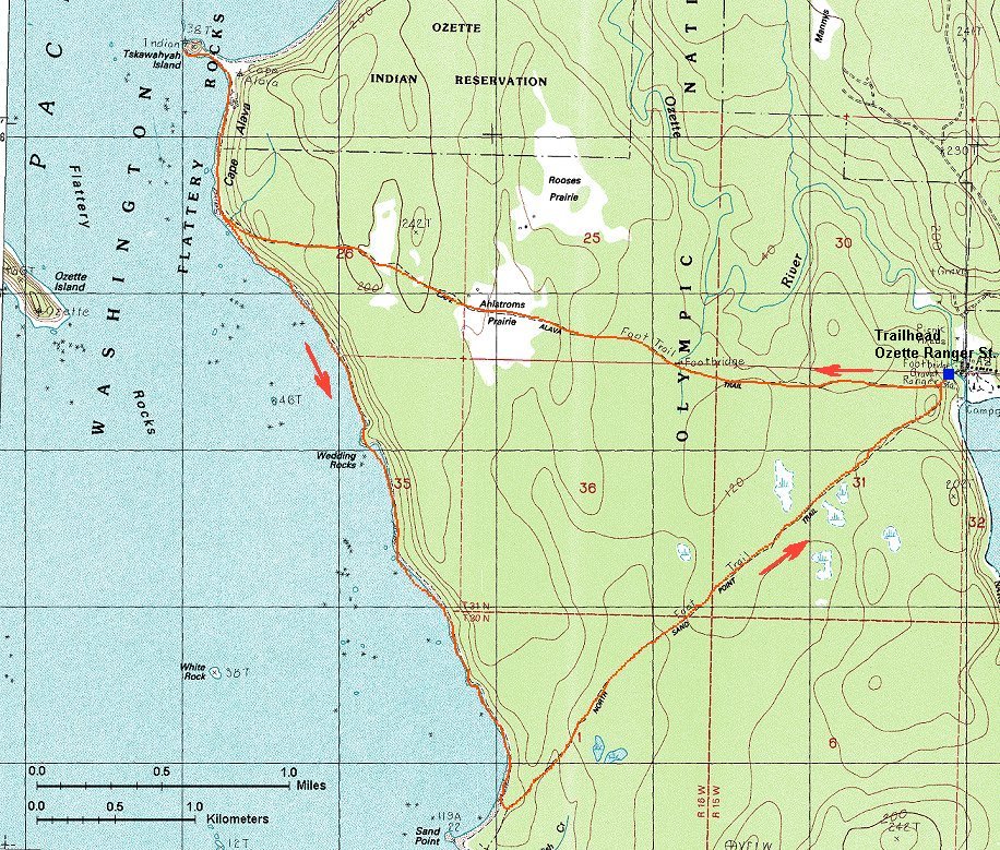
Map of the Ozette Loop trail (315 kB).
It's 3.2 miles from the trailhead to Cape Alava, 3 miles on the beach south and 3 miles back on the Sand Point Trail. Most of the walk to and from the beach goes in a swampy forest on boardwalks. It was a low tide at the beach which enabled us to study sea creatures. There were not too many. Some fish and crabs in the tidal pools and seals lying on the rocks sticking out of the ocean. Binoculars came in handy.
Boardwalk in the forest at the Cape Alava Trail.
Deer in the grassy area at the Cape Alava Trail.
Beach panorama where the Cape Alava trail hits the ocean.
Panorama from Cape Alava north-west-south (250 kB).
Cape Alava detail from a bit south.
Another deer near the beach.
Rocks about 2/3 way down the beach towards the Sand Point.
Standing rock in the low tide area.
And another, bigger one, closer to the coast.
Rainforest in the Quinault area
Tent in the rainforest campsite.
Three mossy shots from the Quinault rainforest nature trail.
Tree growing from a stomp.
Cape Disappointment and Columbia R. estuary
A lighthouse near Cape Disappointment, on the Wa. side of the Columbia estuary.
View north from the same spot.
And view south.
Lighthouse at the Cape from the Lewis & Clark museum.
North jetty of the Columbia estuary.
Panorama from the lighthouse at Cape Disappointment east-south-west.
A quite large dead fish.
And a tiny cove where it was found.
Shoshone Falls of the Snake River
Panorama of the Shoshone Falls.
Snake River downstream from the falls.
Back Comments, questions
U of U / Chemistry / HEC / Voth Group / Cuma / Travel / English / Northwest 00
URL: http://voth.chem.utah.edu/~mcuma/nw00e.html
Last updated: 30-Aug-00 / mc