model
valid
The model valid time: YYYY-mm-dd_HHMM
fxx
The forecast lead time: 0-18 for hrrr and hrrrX. 0-36 for hrrrak
location
- Mesowest ID: WBB
- latitude,longitude: 40,-110
dsize
- full: the full model domain
- small
- medium
- large
- xlarge
- xxlarge
- xxxlarge
background
- arcgis: basic terrain/shaded relief
- arcgisSatl: satellite image
- arcgisRoad: roads
- terrain: model terrain
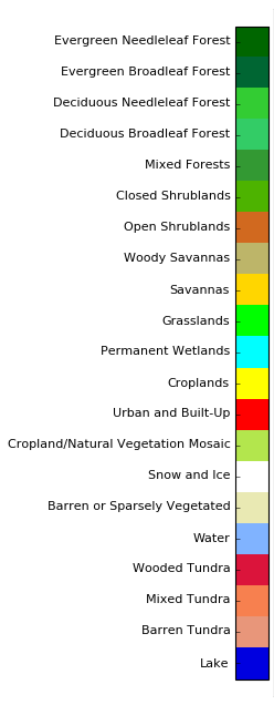
- landuse: model land surface classifications
- none: plain white background
If dsize=full, then the background will be a plain tan for land and light blue for water
plotcode
In general, requires 3-4 parts per code, separated by an underscore. Plots can be stacked by including many plotcodes, each separted by a comma.
[variable]_[level]_[plot type]_[contour interval (optional)]
- TMP or DPT
- 2-m
- 500-mb
- 700-mb
- surface
- Fill
- Contour
- contour interval is [0] by default
- custom contour intervals is numbers separated by a c. Example: '0c10c20c'
- p05p95: 5th and 95th percentile depression/exceedance. (only for level=2-m)
- Wind
- 10-m
- 80-m
- 250-mb
- 500-mb
- 700-mb
- Fill
- p95: 95th percentile exceedance. (only for level=10-m or 80-m)
- Shade: Shade areas with high winds
- Barbs
- Quiver
- Vorticity
- Convergence
- RH
- 2-m
- 500-mb (computed from TMP and DPT)
- 700-mb (computed from TMP and DPT)
- dBZ: simulated composite reflectivity
- entire
- Fill
- Contour
- contour interval is [10,20,30,40,50] by default
- custom contour intervals is numbers separated by a c. Example: '0c10c20c'
- APCP: Accumulated Precipitation
- surface:0 (accumulation since f00)
- surface (accumulation for previous hour only)
- [any HRRR variable abbreviation]
- [any level available for that variable]


