Biking around Salt Lake

The mountains around Salt Lake offer some excellent mountain bike trails. When they are under snow, some areas west of the town, and in the foothills are good also.
As for the road bike, any canyon in the Wasatch Mountains with a road (except Parley's, through which goes I80) are good, but beware of locally heavy trafic.

Mountain bike

Some trails in Wasatch Mountains are pretty good (not too steep, and locally technical), some ar just steep way up and brake all the way down. Also, Wasatch gets snowed on in late October. Then it's time to head away from Wasatch, either south, or smaller mountains around SLC.

Wasatch:

Little Cottonwood Canyon
Big Cottonwood Canyon
Millcreek Canyon
Other:
North of SLC
South of SLC
West of SLC
East of SLC
Uinta Mountains
Weekends farther from SLC

Wasatch - Little Cottonwood Cyn

Grizzly Gulch

Old mining road that goes from Alta east towards Brighton. It is moderately steep most of the time but there is couple of rough spots with loose rocks which require pushing. About 1/2 mile below the Twin Lake Pass (end of Grizzly Gulch), there is a old mining track left (north) which leads to the Prince of Wales mine, a nice mile or so of singletrack.
Here is
a map (200 kB).
Fotos:
fotoFixing a bike on the top of Twin Lakes Pass.
fotoMisha on the last stretch towards the Prince of Wales mine.
fotoGoing down on the worst rocky section.

Germania Pass

In Alta, the trail goes on a gravel road kept by the skiing resort. From the bottom of Alta is is about 5 km to the Germania Pass, 1800 ft. elevation, then down the other side of the pass, total ca. 15 km, ride time max. 2 hours.
On the last August Saturday 1999, me and Aaron rode our mountain bikes from the bottom of the Little Cottonwood Canyon (ca. 1600 m) to the top of Sugarloaf Lift in Alta (ca. 3200 m) and then hiked to the top of Mt. Baldy (3374 m). Another friend Justin joined us for a ride from Alta up and on the hike. On a fun side. I was so trashed on the top that I forgot there a lock that we used to lock the bikes while hiking to the Baldy. First time I was back there, almost 11 months later in mid July 2000, I found the lock and it was working perfectly. Good I have saved the keys.
foto The three of us on top of Mt. Baldy, view to the West, one American Fork Twin (the higher one) and Pfeiferhorn in the distance.
foto Me and Aaron with the bikes in the Sugarloaf saddle, Albion Basin in the background.
foto Me and Aaron with Mt. Timpanogos in the background.

Hidden Peak

The highest point reachable on the bike around SLC, 3251 m. Access via a gravel road belonging to the Snowbird ski resort. About 5 km long, elevation gain about 2500 ft., it took about an hour to get up, 15 min. down.

White Pine Lake Trail

Former jeep road, now used only by hikers and bikers, so it is quite rocky. I had to push several times. Length about 9 miles roundtrip, elevation gain 2460 ft., ride time min. 3 hours.
fotoMy bike and the lake, Broads Fork Twin Pks. and other peaks between Big and Little Cottowood in the background (225 kB).

Alta - Sugarloaf Pass - Mineral Basin - Hidden Peak Supertour

With White Pine probably the worst which can be done in the Little Cottonwood. From the upper Alta lifts it is about 6 km, 550 m. vertical up to the Sugarloaf Pass. From here leads a trail south down to the Mineral Basin. Unfortunately, only about 60% is rideable, the rest is very loose because of ATVs. Down it is about 300 m vertical, a couple km long. From Mineral Basin goes a new lift service road up to the saddle east of Hidden Peak and from there up to the summit (or better to say to a building that houses top of the Snowbird tram). This can be about 450 m. vertical, 3-4 km long. Then follows a wild ride down and up the road back to Alta. Total elevation climbed is about 1000 m. length ca. 18 km, ride time a bit over 2 hours.
Here is a map (350 kB).

Little Cottonwood Pipeline

Short trail, going up the canyon about 6 km from the canyon base. Elevation gain is about 250 m. After about 5 km there is a connection trail to the L.C. road. The trail is mostly moderate uphill with packed gravel or sand, however, there is several steeper sections with embedded rocks, which require some concentration and technique.
Here is a map (150 kB).

Wasatch - Big Cottonwood Cyn

Solitude Ski Resort

Solitude has made several trails and operates one lift during the weekends. This means that the trails get messed by the downhillers by mid summer. All the trails can be ridden in several hours, without using the lift. I rode up the lift service road to the top of the Summit lift (the last stretch if very steep, I had to get off several times), and down on the singletrack to the bottom of the resort (quite nice trail). Another downhill singletrack starts just below the Roundhouse restaurant.
fotoView from the top of Summit lift to the Twin Lakes reservoir and Brighton.

Wasatch Crest Trail - as a loop

Me and my bike partner Gary share an idea to avoid car shuttles as much as possible. I rather sit on the bike than in the car. To do this loop, park the car at the Mill D North trailhead in the middle of Big Cottonwood (ca. mile 10) and bike up the road up, turn off to the Guardsman Pass road and then go to the Smith's Pass trailhead. This is about 8 miles road ride, but that's what the roads are for. Then there is further mile or so climbing, but this is already on the official Wasatch Crest trail. This is followed by miles of rolling singletrack. For those tired, one can turn off down towards the Desolation Lake. The crest contiunes further, and then drops into the Millcreek Canyon. After a couple of miles of downhill, turn left towards the Dog Lake (does not have this name in vain, we saw tens of dogs swimming there during the ride - the water looked worse that sewage). What follows is a seemingly endless climb aggravated by tired legs. From the Dog Lake, it is just downhill via Mill D North to the car. Don't forget that Millcreek Cyn. allows bikes only on even days. Doing the Desolation Lake shortcut one stays all time on the Big Cottonwood side so this can be done any day.
Here is a trail map (150 kB).
Fotos:
fotoOn the top of the crest climb, looking towards Brighton.
fotoPanorama from the same spot (200 kB).
fotoAbove Desolation Lake. The trail right of the lake is the above mentioned shortcut.
fotoRidge above Desolation Lake looking north.
fotoAt the trailhead after the ride.

Wasatch - Millcreek Cyn

Millcreek Pipeline

Trail follows old pipeline thru about a half of the Millcreek Cy. length. Up on the road to the Elbow Fork, ca. 5 miles, then down on a singletrack, which goes mostly horizontal but occasionally drops down sharply. About 1.5 ride time.

Upper Millcreek

Here are several trails going up east and connecting to the Wasatch Crest Trail. The mountain bike are allowed only on even days. The trails are generally moderate, with some technical spots. No killer uphills like in Alta and Snowbird. The main problem is that this area us often crowded.

North of SLC

Antelope Island

Island in the Salt Lake. It is rather hilly, especially its southern part. We went here in the middle of November.
foto
View on the flatter southern part of the island.
foto.View to the southwest, with Oquirgh Mtns. on the horizon, on the southernmost place we got.
fotoTrail to the other side, i.e. north.
fotoView to the east, across the Salt Lake to the snow-covered peaks of the Wasatch Mtns.

newSkyline Loop Trail

How does 29 miles of singletrack on a 40 mile loop sound like? That's what the Skyline Loop is. The recommended start from Gregg Bromka's book is at the Pineview Trailhead at the eastern side of the Ogden Canyon. I have learned to take his advices seriously, so I did the loop according to his directions. As usually, his way was the most reasonable. I started at about 8.45 am. The trail does not waste elevation and starts climbing immediately. It does not look too much travelled, as there are shrubs hugging it all the time. I was about 1 mile up when I bent a rear derailleur. A stick (from those damn shrubs) got into the wheel and before I realized, it acted as a lever on the derailleur. I spent the next hour trying to fix it with the stone age tools (actually, I had the tools to take it our, I just tried to unbend it with two stones). The repair was semi-successful. The frame bit holding the derailleur was bent as well, which I found out only during a more involved repair at home. I was able to use the highest and lowest rear gears, the middle ones were skipping. Back to the trail. I did not have much time to think about my misery, as the trail continued to climb for another 8 miles to the Lewis Peak, total elevation gain 3100 ft. The last 2-3 miles were pretty mellow, though, going up and down on the ridge. After a break and first powerbar, I went on, better to say, down, to the North Ogden Pass, 6 miles away, dropping about 2000 ft. The trail was alright (more travelled), but there were two tricky rocky sections. I got here at about 12.15 pm, and went on to another grind, 6.5 mile 2500 ft. climb to the base of Ben Lomond Pk. I had to take several brakes, as the legs were already feeling the distance and elevation. They were not dead, though, so I ended up going up Ben Lomond. I went considerably slower, and pushed more, than a week before, but ended up there at about 2.15 pm. I left at bout 3 pm, and it took me good 1:15 hr to get down to the North Fork Trailhead. The trail down was pretty wicked, especially the last mile before the trailhead, the trail was covered with loose rocks. I rehydrated at the adjacent campground and set off for a 10 mile road ride to the car. It ended up to be quite pleasant ride, mostly downhill, so it took me only about 1/2 hour. Total time 8 hour, a bit under 6 hours of that riding.
Here is a
trail map (565 kB).
fotoPineview Trailhead.
fotoPanorama from Lewis Peak (395 kB).
fotoMe on Lewis Peak.
fotoZoomed up view to Ben Lomond.
fotoZoomed up view to Mt. Ogden.
fotoView to the North Ogden Divide from the to of South Skyline switchbacks.
fotoOne of the rocky sections in the descent to North Ogden Pass.
fotoSteep and rocky switchbacks in the middle of climb to Ben Lomond. This and the section right before the summit are the only ones that require a longer push.
fotoTrail to Ben Lomond above these switchbacks.

Views from Ben Lomond:
fotoPanorama from Ben Lomond (350 kB).
fotoZoomed up view to the Willard Bay.
fotoZoomed up view to the North Fork Trailhead.
fotoZoomed up view to the South, Mt. Ogden and Ogden.
fotoZoomed up view to the North, Willard Pk. and Cache Valley.
fotoView to the North Fork Trailhead from about half the descent.
fotoView to the North Fork Trailhead from almost down.
fotoPineview Reservoir from the Pineview Trailhead.
fotoMy car and bike at the end of the ride.

newNorthern Skyline - Ben Lomond Trail

This trail starts at the crest of North Ogden Canyon at ca. 1885 m. First it switchbacks up north to the ridge, at ca. 2500 m, then it flattens up once in a while or moderately climbs to the base of Ben Lomond Peak, about 6.6 miles from the trailhead and about 2650 m. Then there is the last 1.5 mi. to the Ben Lomond summit at 2960 m. The trail switchbacks up, but there is not too many spots when it's necessary to push, maybe 200-300 m. in total. The ride down the ridge was a blast, definitely worth the climb. Timing at moderate speed a bit under 3 hours up, a bit over 1 hr. down (including prolonged discussions with other bikers, and fixing a flat tire).
Here is a
trail map (200 kB).
fotoView from the first switchbacks to the No. Ogden Pass with the trailhead parking lot.
fotoThe trail up to the ridge.
fotoView from a bit higher to the western portion of the No. Ogden Canyon.
fotoReaching the ridge, slightly imperfect panorama towards the east.
fotoWestern flank of Ben Lomond from the trail on the ridge, near the Chilly Pk..
fotoMisha on the ridge.
fotoBen Lomond (left) and Chilly Pk. (right) from the ridge.
fotoView south with the trail visible on the ridge and Mt. Ogden in the background.
fotofotoA snake that visited us on the summit of Ben Lomond.
fotoMisha on the summit (we had to drag the bikes up about 20 m. from the trail to the summit in order to take these pictures).
fotoMe on the summit.

West of SLC

Stansbury Island

Another island, or better to say peninsula in the Great Salt Lake, this time on the southwestern side. The island is accessible on a dirt road thru mud flats. The trail itself goes on the hills in the southern part of the island. We took the trail on Sat. afternoon and then stayed overnight on a roadside beside the Lakeside Mountains. On Sun. we quickly drove to see the Boneville Salt Flats, which were a bit disappointing, because they were filled with water.
foto
Western side of the island.
fotoSoutheastern side of the island, with Oquirrh Mtns. in the background
fotoAnother view at the Oquirrhs.
fotoCamp beside the dirt road.

South of SLC

Ridge Trail 157

This trail follows the ridge of the Wasatch from the upper part of the American Fork Canyon south towards the loop road around Mt. Timpanogos. We made this into a loop, starting at the Tibble Fork reservoir, then pedalling up for about 2 hours on a dirt road to a pass and start of the ridge trail. This is followed by wild stretch of singletrack which seems to never end, as it goes up and down along the ridge. The loop is completed by nice descent down the Tibble Fork trail to the reservoir. The ride took as a bit over 4 hours and somewhat around 35 km long, with at least 1200 m elevation climbed.
Here is a
trail map (260 kB).
Fotos:
fotoStretching before the ride.
fotoThe dirt road up the pass. ATV density was medium (one in ca. 5 min.).
fotoIn the pass where the singletrack starts. The trail is hidden in the forest in the middle of the picture.
fotoBefore the climbs towards the Mill Canyon Peak, view north-west. Forest Lake below and Little Cottonwood mountains with American Fork Twins in the middle (230 kB).
fotoView from the southwestern slope of Mill Canyon Peak towards Mt. Timpanogos. On the right is the pass through which the trail goes (300 kB).
fotoView west down via Tibble Fork to the American Fork Canyon, Timp on the left (215 kB).

newDiamond Fork - Strawberry Ridge

A whole day adventure trail (ca. 24 miles long), mostly singletrack and jeep roads, about 20 miles SE of Provo. We approached it the standard way up Diamond Fork road, unfortunately, the road is closed about 3 miles from the trailhead due to a construction of a water tunnel. We tried to tunnel through, but were stopped by construction workers. After a fierce word exchange and threat having and escort we backed off. So be warned, the construction lasts till June 2004. After a while of thinking, we figured that alternative is to go to the Rays Valley Road (about another 15 miles up Spanish Fork Canyon). The drawback of this approach is that the last ca. 5 miles is a 2000 ft. climb up Cottonwood Canyon. We got to the crossing of the trail with the road at about 1pm, quite late. In about and hour, we got to the Strawberry Ridge, which provided great views of the fall-colored southern Wasatch and a pretty good doubletrack. After few orientation problems we successfully found the unmarked turnoff to Fifth Water Fork, and what followed was about 8 mile descent. We stopped for a while at the hot springs, just to feel the water and wash the face. Probably because of the road closure, there was nobody there. The last 1.5 hours were marked by ascent up Cottonwood Cyn. It was not that bad, the trail was mostly moderately steep and the surface was good.
Here is a
trail map (300 kB).
Fotos:
fotofotofotoFirst service stop about 1 mile up Second Water Fork.
fotoFixing Allan's rear wheel at the same spot.
fotofotofotoLee, Gary and Sharon somewhat more up Second Water.

fotoPanorama towards SE from Strawberry Ridge about 1 mile from the intersection with Second Water (170 kB).
fotoPanorama from south to north via west from Strawberry Ridge a bit further up north (235 kB).
foto360 deg. panorama from one of the highest points of the ride (330 kB).

fotoResting after first part of the wild descent down Fifth Water Fork.
fotoThe trail goes much more down.
fotoLee crossing the Fifth Water Creek.
fotofotofotoThree shots of hot springs in the lower part of Third Water.
fotoSharon going down in a pictoresque setting below the hot springs.
fotoSandstone formation a bit below.
fotofotoMe crossing the bridge of the Sixth Water Creek.
fotoTrailhead at Diamond Fork.
fotofotofotoAllan, Dave and Gary and Sharon and Lee reaching crossing of the Rays Valley Rd. and First Water Fork.
fotoPanorama north from Rays Valley Rd. towards Second Water (180 kB).

East of SLC

Big Mountain - Lookout Pk. loop

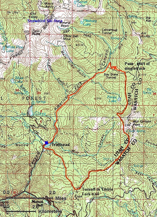
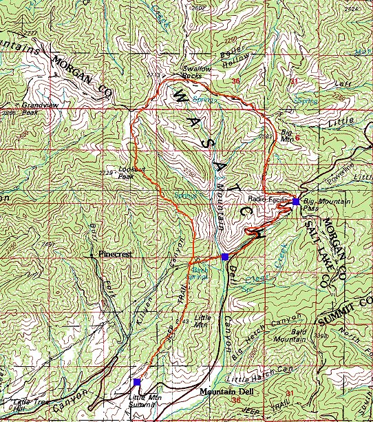
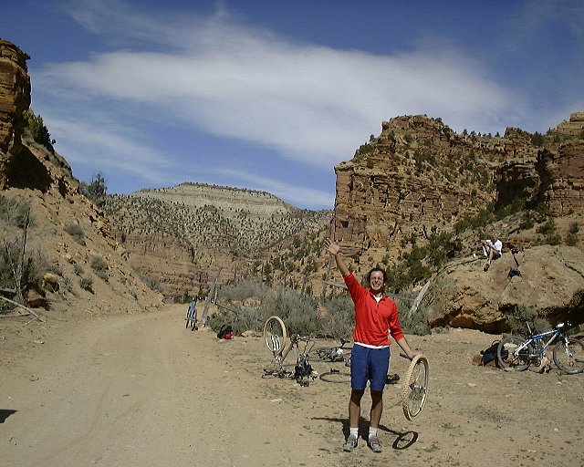
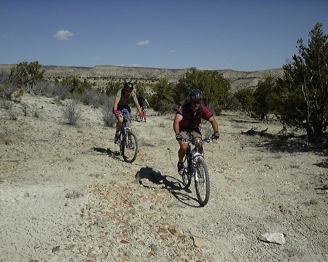
One of the wild rides closer to SLC. Gregg Bromka suggests to start in the Affleck Park in the middle of Mountain Dell Canyon, about 17 miles from downtown SLC. Me and Gary, decided, for a warm up, to start at the Emigration Canyon summit, ca. 5 miles closer to SLC. One can ride on a decent singletrack on the Little Mountain ridge towards the saddle above Affleck Park, about 2.5 miles one way. The trail was not just a moderate climb up, as it looked on the map. The second half was marked by several steep descends followed by similarly steep ascends. Not a good perspective for a way back. The ride down to Affleck Park was unevetful, I again got a chance to give a good test to my new Mars shock on a bumpy doubletrack. What followed was a 3.5 mile 1200 ft. climb to the Big Mountain Pass. We lunched there unaware of a very sucky uphill singletrack, that followed. This was the only downside of a great loop, steep, loose trail did not give much chance to get into the saddle. However, once on the ridge the fun part begun. Rocky singletrack, and then doubletrack to Swallow Rocks, and turnoff to another singletrack. Gregg says the trail after here is primitive, however, it was more used than I expected. We even met a pack of five riders on the west side of upper Mt. Dell Cyn. ridge. Here the trail goes almost level few hunded feet below the ridge for a couple of miles, and then plunges down towards the saddle between Killyon and Mt. Dell Cyns. From here we retraced our steps from the morning, arriving back to the car after 5.5 hours.
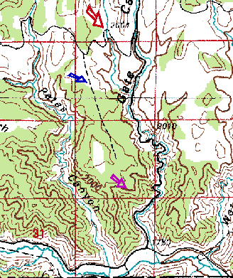
Here we have two maps.
Detailed 24k map (870 kB) and less detailed 100k map (235 kB)
Fotos:
fotoEmigration and Parleys Cyns. panorama from the Little Mountain ridge.
foto
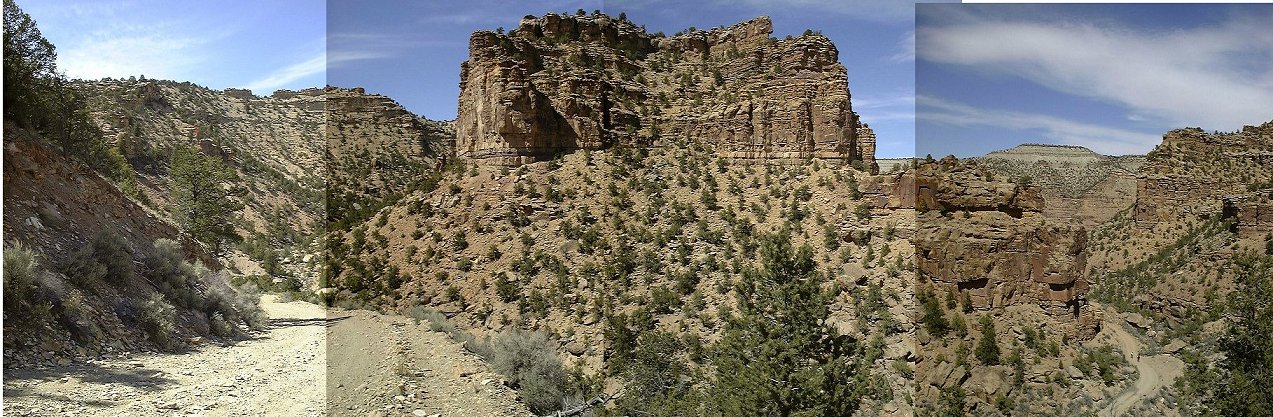
Panorama south from the Big Mtn. trail switchbacks, the road below, high Wasatch in the distance.
fotoView east from the Big Mtn. climb at yet another point where I had to get off the saddle.
fotoThe trail continues up to the summit.
foto360 deg. panorama from the ridge close to Big Mtn. We came from where Gary is and continued on the ridge past Big Mtn. Note Gary's orange jacket. The hunting season is in full swing.
fotoSecond lunch break area at the doubletracked ridge, view east, Swallow Rocks in the background.
fotoView from the same spot east where we came from.
fotoTrail that descends from Swallow Rocks.
fotoRidge panorama from under Swallow rocks.
fotoView north towards East Canyon.
fotoGary negotiates, in the Vancouver style, the only big obstacle on the western side of Mt. Dell ridge.
fotoAnd the trail keeps on winding in the aspens.
fotoAnother panorama from one of the clearings on the western Mt. Dell ridge.
fotoPanorama of the Wasatch Front canyons before the descent to Little Mtn. ridge.
fotoDown at the junction Killyon - Mt. Dell Cyn.
fotoAnd view up at what we came from.
fotoGary pushing up one of the steep hills on the Little Mtn. ridge.
fotoTo be followed by another downhill.
fotofotoMore gentle lower ridge, views down and up.
fotoThe last shot, trailhead at Emigration summit.

Park City

PC is a Mecca for the mountainbikers. The slopes of Park City and Deer Valley ski resorts are full of trails from the easiest to the most difficult. As of summer 2000, I drive to PC every Thursday evening for group rides organized by the White Pine bike shop. The area is so complex that one could devote a whole website to it, so I stop here.

Uinta Mountains

Soapstone Basin

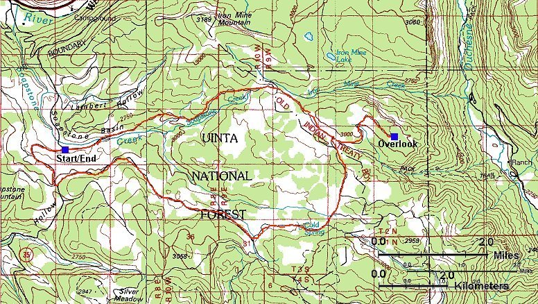
About a 16 mile dirt road loop in the southwestern part of the Uintas. The road itself is uneventful, standard dirt road with frequent ATVs and motorcycles. One half is a slow but steady climb up, the other a relatively fun ride down. The only highlight is the Bluffs overlook about 1.5 mile east off the loop, overviewing the Duchesne River gorge in the east.
Here is a
trail map (200 kB).
Fotos:
fotoMisha almost on the top of the climb.
fotoPanorama from the Bluffs from west to east (230 kB).

Notch Mountain Trail

Quite tough ride in the heart of western Uintas, rated moderate to extreme in Gregg Bromka's Wasatch & Uintas MTB bible. It is pretty extreme at parts, we rode cca. 75%, walked the rest. I would say that out of the 75%, a third was ridable with difficulty, mainly up or downhill with loose or embedded rock. Length is about 8 miles, but took us about 3.5 hours of ride/walk time. The unridable part was steep rocky sections, rock steps and boulder fields. We started the trail at Trial Lake and there were only few challenging sections for about a first mile, which I managed to clear all. As I stated to feel good about myself, the first climb toward the Wall lake came whihc brought me back to the reality. Then the trail flattened for a while, followed by a brutal ascent to the Notch Pass, which had to be mainly walked. From the pass down, there were some unridable sections, but not very long. Mostly it was a slowly descending pine covered trail with occasional rock areas. From the intersection east of Meadow Lake, the trail ascends again, mostly covered with loose rocks. My tactics was to hammer up until I was out of breath or the trail was too difficult, push for a bit, and ride again. This was repeated about five times which seemed to be enless, until I reached Bench lake. From here, the trail is almost flat, but not eventless. There are numerous rocky areas which require occasional descent. The stretch south of the Bald Mountain again requires a lot of walking, since the rocks on the trail are just too big. Overall, highly scenic but highly difficult trail.
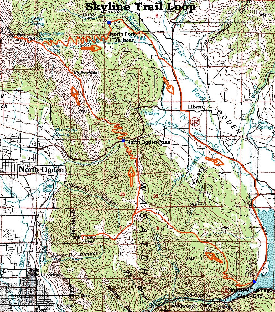
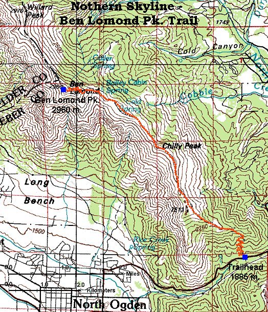
Here is a trail map (200 kB).
Fotos:
fotoMisha on the last stretch towards the Wall Lake.
fotoWall Lake panorama.
fotoPanorama from the Notch Pass south, Wall Lake in front, Trail Lake where we started in the back left.
fotoMe in the Notch Pass, still feeling pretty good.
fotoMisha about mile from the trail end, not feeling that good anymore.
fotoTrail as it goes on from this point.

Weekends farther from SLC

Nine Mile Canyon

This canyon is good 50 km long and several hundred meters high, southeast of Price, ca. 3 hours away from SLC. On its bottom is a well maintained dirt road. Each several kms, there are side canyons, in which are often roads or trails, which are well suited for biking.
Wee took one like this on Sat. afternoon, up via Harmon Canyon, down Prickly Pear Canyon. foto
Here is the ride start. The ride down Prickly Pearfotolooked like this. During the ride down, I managed to punch read tire, fotohere is me during the repair. Then we had to wade the Nine Mile Creek to get back to the main road. Different people chose different methods. fotoHere can be seen both that were used. fotoHere is shot a bit later, from which can be seen which one was more successful. Here is the trail map, start is at the red arrow, end at the blue. In the evening, we settled on a fotovery nice spot.
fotoIn the morning we got up slowly and prepared for another ride. This time there was no plan. We drove up the road out of the canyon and biked off one turnoff. Then we took another, fotomore faint turnoff south, towards the canyon. fotoHere is a picture where we went, the trail is in a juniper-pine forest marked by the arrow. We rode as long as we could, till we reached a cliff from which there was fotothis view. Here is the ride map. We started on the road marked by red arrow, followed the dirt road marked by the blue and ended up on a cliff with the violet. All that remainded was to pack up and drive back to SLC.

Road bike

Smetime to come.


Back Comments and questions


U of U / Chemistry / HEC / Voth Group / Cuma / Travel / English / Bike
URL: http://voth.chem.utah.edu/~mcuma/bike_en.html
Last updated: 09-Oct-00 / mc