Thu. 5/10 - Drove out of SLC at 6.30am, arrived at Sundance Trail trailhead at 11.30am, set out hiking at 12pm, with an 1/2 hr. break at the bottom of Sundance trail, arrived at the campspot at the bottom of Lost Canyon at 3.30pm, relaxed, hiked up Lost Canyon up and down for about 1.5 hr.
Here is the photo tour of Day 1
Fri. 5/11 - Hiked upstream, started at 8.30am, got to Youngs Cyn. around 12.30pm, turned around at about 13.30pm, went for a swim several times on the way back, arrived back to the campspot at 6pm.
Here is the photo tour of Day 2
Sat. 5/12 - Hiked downstream, started at ca. 9.30am, arrived to Colorado River at ca 12pm, had a lunch, went for a swim in a pool about 1 mile upcanyon from the confluence, in about 45 min hiked up Lean-to canyon to a big alcove, got back to the camp at ca. 5.30pm.
Here is the photo tour of Day 3
Sun. 5/13 - Hiked out in the morning, started around 8am, arrived to the car at 11am, drove to Hite for a quick refuel stop, then hiked Hog Springs Canyon off Hwy 95 till 3pm, and then drove home.
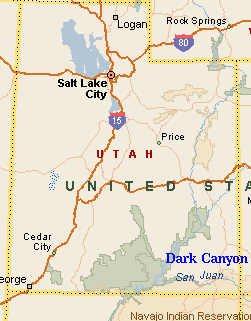
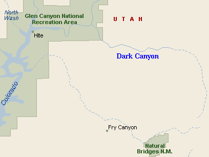
We left Salt Lake very early, but that was not that bad driving-wise. With a couple of stops, we got out hiking around noon. Location of the Sundance Trail was not hard at all, with the Trails Illustrated topo map. Only the road numbers on the road were slightly different than on the map. There were about 8 cars parked in random order, mostly in the shade of junipers or pinyon pines. It is about 2 miles mostly flat walking to reach the canyon rim, this probably took us somewhat over an hour. Then the trail plunges down the slope about 1200 ft. to a small side tributary of Dark Canyon. Walking down was somewhat annoying, mostly due to lose rocks. Walking in the mid-day heat also did not help. We stop for some rest at the bottom of the side canyon, and then continued for another ca. 15 min. towards the Dark Canyon creek, and then upstream for less than a mile to the confluence with Lost Canyon, where we found a nice shady campspot under a cottonwood group, with a soft sandy bottom and several rocks to sit on. I would argue that this was one of the best spots I have seen in the canyon. We were pretty tired, probably a mix of geting up early, sitting in the car for 5 hours and the heat. We have built the tents, and at ca. 4.45pm went on to hike up Lost Canyon. It was mostly easy walking on rock slabs, with few scrables up the rock steps, until we came about 8m pour-off with a pool on the bottom. It was possible to climb about half the height on a rock bench, but then there was the last bit with a crack between a boulder and the pour-off itself, which required some more sophisticated climbing. I think it would be doable, but I did not feel like doing it at this time. So we turned around and walked back to the camp. Then we roasted some sausages and relaxed, listening to a frog symphony and bats acrobatics.
Friday was dedicated to walking upcanyon. The plan was to hike to the Youngs Canyon, guessing about 7 miles away. First hour or so was pretty smooth, walk on the rock benches, limestone, then sandstone, then limestone again,... Sometime, there was a sand bar or a rocky section. Then the trail stays on one of the benches while the creek flows in a narrow ca. 5m below. Here we caught up with two young couples with backpacks, who woke us up in the morning while walking past our tents. Walking in the creek did not look attractive, so we had to climb up the slope a bit to bypass several rock slabs, and lost the trail. We then continued about 300m on a slope higher above the creek and then walked into a small side canyon and back into the stream bed. On the way back I found out, that one could walk several benches lower and then get into the creek bed, that would be easier than our high route. That small canyon, however, had a little alcove where we stopped for a snack, and noticed a hummingbird flying around. It had a nest on a rock under the alcove. I went to check it out close, while the bird was angrily flying around and swearing at me. One bend after this side canyon is on the south side large alcove, where is shade most of the day, and where would be a nice campspot. The canyon was not too wide, but there were no more rock steps to negotiate, it was mostly walking on rock slabs, gravel or sand, with numerous creek crossings (fortunately, there was not too much water, so rock-hopping was fine). About 2 miles from Youngs, the vegetation on the bottom grows thicker, so we had to do some bushwhacking. Then there is some wetness on the south slope, as some kind of spring leaks in. Mouth of Youngs Canyon comes quite unexpectedly and is fairly narrow. There is a small sandy campspot under a couple of cottonwoods at the confluence. A small waterfall seems to block advance into Youngs, but it's not hard to climb it up on the right side. For those wanting to take it more easy, there is a bypass trail that starts from Dark Canyon about 15m above the confluence, climbing to the north slope. There is quite a bit of water flowing in lower Youngs, and the creek makes nice cascades with several pools. A bit further upstream are several patches of poison ivy. Having been warned about this by another website, we were careful and this paid off. At the top end of the poison area is a very cool spring, running down an alcove on the south side of the canyon like a waterfall. It runs fast, too, and probably creates most of the stream flow. The water disappears from the creek bed only few hundred meters higher. That is where we stopped, had a lunch and turned around. On the way back, we spent a while swimming at the pool in lower Youngs, a nice break in the hot afternoon, and then walked back to the camp. The way back seemed to me much easier than the way up, mainly because I tended to pick up easier routes. Still, it took us about 3.5 hrs, with another small dip in a pool about halfway down, to get back to the camp.
Saturday morning we slept a bit longer, and set out for the hike downcanyon at about 9.30am. The crowds that I expected for the weekend did not show up, we were mostly meeting people that we have seen the day before. The hiking down goes fast till a turn past Lean-to canyon. Then the canyon walls close in again. Next half km or so goes on rock slabs on the creek bottom, followed by another half km high route above narrows. Apart from ca. 2m waterfall, the narrows seemed to be doable, although one would get pretty wet, and probably would have to swim at places. The high route drops down where a side canyon joins in. Then there is another several hundred m. of nice rocky creekbed with several pools and waterfalls, and then the canyon suddenly widens up to 200-300 m., with grass on the ground and the creek meandering around. It's about another mile from here to Colorado River, which was accessible because Lake Powell level was low. There was even some flow still to be seen in the river. The Dark Canyon creek, however, has changed from a clear stream into a muddy trickle, fighting with the Lake Powell mud. We sat in the shade on a small cliff above the river to have lunch. Then we walked back, stopping at the coolest pool, which was right below a series of small waterfalls. This was the best swim of the trip. It came in handy, because the afternoon was pretty hot. In the later afternoon, I walked up Lean-to canyon, for about 45 min. The lowest third is very annoying, the canyon bottom is rocky and hard to walk on. Then one gets on rock slabs, and there are several steps which need to be climbed up. Finally, the progress is halted by a huge alcove, about 35 m. high. On the way back, I have noticed a trail that starts climbing to the right about 100m. above the canyon confluence. This trail seems to bypass the grand alcove high on the right side of the canyon. I got back to the camp at ca. 5.30pm, and went for another dip in the limestone section about 500m. above our camp. There I discovered a nice waterfall, which worked almost like a shower, and finally cooled down from the hot day.
On Sunday we woke up fairly early, and by ca. 8am were on the trail. It was a bit cooler and cloudy, which was nice for the climb up Sundance Trail. I think I have picked up a better way up, than when we went down, this one starts in the side canyon about 100m below the other trail, and is marked by cairns. This trail joins the main one about half way up, and is much less loose. We got to the trailhead in 3 hours, at about 11am, the last hour being a walk on the plateau above the canyon. Then we drove to Hite, where I ate 2 hot dogs, and on Hwy 95 to rest area Hog Springs. From here one can hike upcanyon on the south side of the highway to a small alcovy waterfall with a pool. We walked higher up, hoping to find some slot canyons, but without success. On the way back, we were chased by light rain, but nothing serious. It took about 3 hours to hike up to the springs and to the end of the central canyon, and back. Then we sat in the car and drove home.
U of U / Chemistry / HEC / Voth Group / Cuma / Travel / English / Dark Canyon
URL: http://voth.chem.utah.edu/~mcuma/dark_c01e.html